| A. chaos B. consume C. plentiful D. discharge E. evolutionarily F. extent G. freeze H. mechanism I. novel J. subsequently K. unstable |
Science in Images
Oyster mushrooms feature in cuisines around the world, but they should be off the menu for hungry worms -- which these delicious mushrooms will kill and eat. Now researchers finally know how they do it.
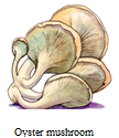
A study published in Science Advances details how oyster mushrooms use a particular poisonous substance to freeze and get rid of mushroom-eating roundworms called nematodes (线虫). The mushrooms, which grow on nutrient-poor dead wood, then
“Nematodes happen to be the most
The study team of geneticists, biochemists and biologists had previously found that oyster mushrooms release an unidentified poisonous substance that will somehow
For their new work, the researchers grew and analyzed samples of the mushroom’s tissue, finding no noticeable poison even when they broke it up. They reasoned that whatever was killing the worms must be a kind of
Before this study, “we underestimated the
2 . Any snakebite can be dangerous if infection (感染) sets in. Some types of snake poison make the bite area swollen (肿胀的) or painful. Others cause bleeding or damage the heart’s nerves. Here are some especially dangerous snakes:
The largest of all poisonous snakes, king cobras can reach 5.5 meters in length. Each king cobra bite contains enough poison to kill an elephant — or 20 people. But these big snakes usually avoid people. They live throughout India, southern China and Southeast Asia.
A bite from Australia’s inland taipan, the world’s most poisonous snake, releases enough poison to kill 100 men. The good news is that people rarely come in contact with this snake, and a treatment for its poison exists.
Russell’s viper lives throughout Asia, including India, southern China, and on the island of Taiwan. It prefers grassy fields but can be found in forests and urban areas. It bites more people and causes more deaths than any other poisonous snake.
Though short, the common Indian krait packs a powerful punch (攻击) in its bite. Most often, it strikes people at night while they are sleeping. Since the bite causes little pain, victims are often not sure that they have been bitten until they begin to experience stomach cramps (痉挛). Without treatment, symptoms will worsen quickly and can lead to death.
The black mamba, a native of Africa, is actually olive or grey in color. Only the inside of its mouth is black. When black mambas feel threatened by a human, they make a loud hissing sound to warn the person away. If the warning is ignored, the snake will attack the person repeatedly. And they can attack quickly, moving over the ground at speeds of up to 20 kilometers per hour.
1. According to this article, what is a particular feature (特点) of the king cobra?| A.Its seasonal changes. | B.Its lack of movement. |
| C.Its sense of hearing. | D.Its amazing size. |
| A.The inland taipan. | B.The black mamba. |
| C.The Indian krait. | D.The Russell’s viper. |
| A.It is believed to have died out. |
| B.Meeting with it can cause death. |
| C.Some people keep one as a pet. |
| D.Very little is known about its behavior. |
| A.Let’s Explore Nature | B.Weekly Travel Digest |
| C.Psychology Magazine | D.Global Warning News |
Loss of Biodiversity (生物多样性) Affects Human Society
If a species of bee disappears forever or a particular plant is extinct, what does it have to do with us humans? Well, according to a team of international scientists, biodiversity is dropping below levels
The issue is that everything is inter-connected and ecosystems support our societies
A framework which defines the environmental limits within
A study published in the magazine Science suggests that 58% of the world’s land surface
The researchers found that grasslands, savannas and shrub lands were most affected by biodiversity loss on average. Purvis hopes this report
| A.They have been sent to wildlife parks for protection. |
| B.Their habitats have been well-protected. |
| C.They have been taken care of by locals. |
| D.Their population has almost doubled. |
| A.She fought against illegal hunting. | B.She helped to cure their disease. |
| C.She improved their living conditions. | D.She was engaged in preserving forests. |
| A.To teach people how to treat gorillas. | B.To boost the economy of Uganda. |
| C.To better the Batwa people’s lives. | D.To raise funds for wildlife protection. |
1.
| A.Educating children. | B.Saving rare animals. |
| C.Recreating an environment. | D.Making a profit. |
| A.Because animals make visitors stressful. | B.Because animals must live their lives in cages. |
| C.Because animals can feel bored and sad. | D.Because animals are in danger of extinction. |
| A.They are still useful and necessary. |
| B.They have more disadvantages than advantages. |
| C.They are a perfect environment for animals. |
| D.They are recreative places for animals. |
| A. steadily B. processes C. environmental D. displays E. covered F. varies G. severe H. influence I. inherited J. fortunately |
Many trees and shrubs change color in fall. For years, scientists have worked hard to understand the changes that happen to them. They find that three factors
The timing of the color change
However, some species are evergreen. Pines, for example, are green all the year round because they have toughened up. They have developed over the years a needle-like or scale-like foliage (绿叶植物), which is
7 . The purpose of a map is to express graphically the relations of points and features on the earth’s surface to each other. These are determined by distance and direction. In early times distance was often expressed in units of time, for example “so many hours’ march” or “a day’s journey by river”, but such measurements gave more information about the relative ease of crossing the local terrain than they did about actual distance. The other element is direction, but for the ordinary traveller, whose main concern was “Where do I go from here?” and “How far away is it?”, the accurate representation of direction was not of primary importance. Partly for this reason, written itineraries (行程) for a long time rivaled maps. Even today, certain types of maps, for example, those showing railway systems, may make little attempt to show true directions. Similarly, obvious landmarks along a route were at first indicated by signs, realistic or conventional (惯常的), and varied in size to indicate their importance. Clearly the conventions employed varied with the purpose of the map, and also from place to place, so that in studying early maps the first essential is to understand the particular convention employed.
The history of cartography (制图) is largely that of the increase in the accuracy with which these elements of distance and direction are determined and in the comprehensiveness of the map content. In this development, cartography has called in other sciences to its aid. For example, instead of determining direction by observing the position of a shadow at midday, or of a constellation (星座) in the night sky, or even of a steady wind, use was made of terrestrial magnetism (地磁学) through the magnetic compass, and instruments were evolved which enabled horizontal angles to be calculated with great accuracy.
The application of astronomical concepts, and the extension of the knowledge of the world through exploration, encouraged attempts to map the known world. Then astronomers discovered that the earth is not a perfect sphere, but is flattened slightly at the poles, which introduced further refinements into the mapping of large areas. Meanwhile, the demands being made of the map maker were shifting significantly. The traveller or the merchant ceased to be the sole user of maps. The soldier, especially after the introduction of artillery, and the problems of range, field of fire, and dead ground which it raised, demanded an accurate representation of the surface features, in place of the earlier conventional or pictorial delineation (描绘), and a solution in any degree satisfactory was not reached until the contour (等高线) was invented.
1. Why might early maps have been misleading?| A.Distances could not be calculated reliably. |
| B.They were based on written itineraries. |
| C.They were drawn by ordinary travelers. |
| D.Distances tended to be overestimated. |
| A.The signs used bore little relation to the landmarks. |
| B.The selection of landmarks was faulty. |
| C.They used symbols that were not standardized. |
| D.They sometimes included unimportant features. |
| A.a greater understanding of climatic factor |
| B.greater accuracy in draughtsmanship (绘图术) |
| C.more accuracy in measurement |
| D.more intensive map production |
| A.Discovery in astronomy. | B.The growth of mathematical science. |
| C.The activities of the great explorers. | D.Military considerations. |


