1 . If you’ve ever worried that we’ve solved all the mysteries of nature, fear not. Minnesota’s Devil’s Kettle Falls has been attracting hikers and geologists for generations. At the falls, along Lake Superior’s North shore, a river forks at a rock outcrop. While one side runs down a two-step stone bank and continues on like a normal waterfall, the other side falls into a deep hole and disappears apparently forever.

And this baffling situation only gets strange when geologists start explaining Devil’s Kettle (水壶). Consider, for instance, the sheer quantity of water pouring into the kettle every minute of every day. While the idea of some kind of broad, underground river is an exciting device in movies, the reality is that those sorts of deep caves are rare.
Another idea is that millions of years ago, a hollow lava tube may have formed beneath the falls, in the subsurface layer of rock. Over time, the theory suggests, the falling water eroded (侵蚀) the surface and fell straight down into the ancient lava tube, providing wide-open access to the floor of Lake Superior. Again, there are problems with this theory, because no lava tubes have ever been found in any of the hundreds of exposed rock beds in the area.
In February 2017, scientists said that water that disappears into the rock at Devil’s Kettle rises again in the stream below the falls. To confirm the theory, scientists plan on conducting a dye trace during a low-water flow period. They’ll pour a vegetable-based dye into the pothole and watch where the dye comes to the surface again.
“What we think is happening is that the water is going in the kettle, and coming up pretty close to immediately downstream of the falls,” Green said.
Green admits that if the dye is found below the falls like the scientists suspect, then much of the Devil’s Kettle Falls mystery will be gone. “Were there a little bit of that,” he said, “the folks would not be going to stand there and wonder. But it will still be a fascinating spot, and a beautiful spot.”
1. What is the purpose of writing the first paragraph?| A.To explain the formation of waterfalls. |
| B.To describe a beautiful landscape scene. |
| C.To introduce a mysterious natural phenomenon. |
| D.To recommend an unusual waterfall to readers. |
| A.Supportive. | B.Curious. | C.Doubtful. | D.Indifferent. |
| A.By tracing the path of the water. |
| B.By controlling the direction of the stream. |
| C.By asking the folks to watch the surface. |
| D.By filling the pothole with a dye. |
| A.The mystery of Devil’s Kettle Falls |
| B.The discovery of Devil’s Kettle Falls |
| C.The disappearance of Devil’s Kettle Falls |
| D.The fascinating features of Devil’s Kettle Falls |
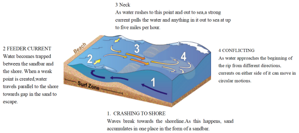
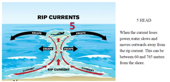
2 . WHAT ARE RIP CURRENTS?
Rip currents are like the rivers of the sea, transporting water near the shore back out into the ocean depths. The presence of these currents can be hidden by the wild movements of the surrounding waves. This means that as well as carrying seaweed and pieces of materials quickly out to sea, they can rapidly sweep away even the strongest swimmers. Around 80 percent of all lifeguard rescues are caused by powerful rip currents pulling a swimmer into danger.
If you find yourself being pulled out to sea by an unsuspected rip current, you should remain calm, focus on staying afloat and, if you can, swim parallel to the shore. Your instincts might tell you to swim towards land, as this is where you’re aiming to get to, but the current will be too strong to swim against. Instead, aim to move across the current and into slower flowing water next to it. A rip current may only pull you just past the breaking waves, but in some cases they can take you hundreds of metres offshore. The strength of currents can be hard to predict, so it’s safest to stay on lifeguarded beaches and not to swim if you see any indication of a rip current.
| A.prevent you from swimming into danger | B.transport water out into the ocean depths |
| C.clear away seaweed and pieces of materials | D.warn lifeguards against rescue in rip currents |
| A.difference between various currents | B.two types of zones off shore |
| C.an ideal route to surf in safety | D.how rip currents form |
| A.1000 metres off the shore beyond “HEAD”. | B.The channel through the gap in a sandbar. |
| C.The location where a red flag is erected. | D.Over the narrow stretch of a sandbar. |
3 . The popular documentary series Aerial China (航拍中国) recently returned to the small screen. The latest and fourth season of it gives a perspective that is both excellent and informative. As the final of the series, the new season was shot across 11 provincial-level regions and started in the spring of 2020.
“The experience from the previous three seasons makes us more capable to follow wild animals while avoiding disturbing them,” says Yu, chief director of the series. China has made great efforts to protect endangered wildlife species and their habitats in recent years, and it has become much easier to spot rare species in the wild. Taking Tibetan antelopes as an example, the plateau-based creatures were difficult to encounter in the past, but the expansion of their population and enhanced research on their living patterns have allowed the camera crew to tailor plans to follow the animals.
Most close-ups for the season were shot by photographers from helicopters or cameras installed on drones (无人机). The vital moment for a successful shot depends on the mood of the animals or how good the weather is,” Yu says. In an attempt to fully show China’s huge changes over the past decade, the documentary series consulted experts from different fields to help select the most attractive shooting sites. In the final season, Aerial China has used 73 helicopters and 320 drones to shoot footage over an area of 900,000 kilometers, and selected around 1,000 staffers. More than 30 teams were assigned to shoot in different cities for the fourth season.
The previous three seasons have been watched by 850 million TV viewers and seen online over140 million times. For fans of the series, the director says he hopes that the new season will draw a bigger audience with its unusual perspective to show them China like never seen before.
1. Which can best replace the underlined word “perspective” in the first paragraph?| A.Reference. | B.Viewpoint. | C.Mention. | D.Standard. |
| A.To indicate a successful encounter. | B.To introduce new living patterns. |
| C.To show a biological improvement, | D.To save endangered wildlife species. |
| A.The team members’ roles. | B.The splendid shooting sites. |
| C.The hi-tech devices for shooting. | D.The efforts spent in the season. |
| A.This is the last but one season. | B.This season is well worth viewing. |
| C.The series is popular with TV reviewers. | D.The series is intended for Chinese fans. |
4 . The Best Caves in The World
Hang Son Doong, Vietnam
Natural caves don’t come much larger than Hang Son Doong, close to the border between Laos and Vietnam. This cave possesses the largest cross-section of any known cave on the planet, a vast area that is difficult to describe. Supposedly, a Boeing 747 could fly through without damaging its wings, but that doesn’t really do justice to the vastness of Hang Son Doong. The stalactites (钟乳石) here are pretty massive too, with some reaching up to 80 metres.
Waitomo Caves, New Zealand
Glowworms (萤火虫) are there, as far as the eye can see. Okay, not literally, but the Waitomo Cave system on New Zealand’s North Island is best-known for the fluorescent fauna that light up the walls, giving it the not-particularly-creative but completely acceptable “Glowworm Caves” nickname. They are more accessible than other caves on this list, with rafting and adventure tours available to those looking for something a little more thrilling.
Mammoth Cave, the USA
If you have certain expectations from somewhere called “Mammoth Cave”, that is entirely understandable. Mammoth Cave in Kentucky is the world’s longest known cave system, an incredible 420 miles of underground wonder. That’s twice as long as the next longest, by the way, although it isn’t unusual for the USA to go all out on such things.
Reed Flute (芦笛) Cave, China
Named after the reeds that grow outside, which are used to make flutes, obviously, the Reed Flute Cave’s walls are covered with inscriptions from centuries gone by—if evidence was needed that people have been paying attention to this place for a long old time. The inside part of the cave is also lit up by multicoloured lights, giving it a real otherworldly theme that adds weight to the nickname.
1. What is special about Hang Son Doong?| A.It was once a base of a factory. |
| B.It is the deepest cave in the world. |
| C.It has the highest stalactites in the world. |
| D.It owns the largest cross-section in the world. |
| A.Hang Son Doong. | B.Waitomo Caves. |
| C.Mammoth Cave. | D.Reed Flute Cave. |
| A.Vietnam. | B.New Zealand. | C.The USA. | D.China. |
5 . In the 1960s, while studying the volcanic history of Yellowstone National Park, Bob Christian-sen became puzzled about something that, strangely, had not troubled anyone before he couldn’t find the park’s volcano. It had been known for a long time that Yellowstone was volcanic in nature—that is what accounted for all its hot springs and other steamy features. But Christian-sen couldn’t find the Yellowstone volcano anywhere.
Most of us, when we talk about volcanoes, think of the classic cone(圆锥体)shapes of a Fuji or Kilimanjaro, which were created when erupting magma(岩浆)piled up. These can form remarkably quickly. One day in 1943, a Mexican farmer was surprised to see smoke rising from a small part of his land. In one week he was the confused owner of a cone five hundred feet high. Within two years it had topped out at almost fourteen hundred feet and was more than half a mile-across. Altogether there are some ten thousand of these volcanoes on Earth, all but a few hundred of them extinct. There is, however, a second less known type of volcano that doesn’t involve mountain building. These are volcanoes so explosive that they burst open in a single big crack, leaving behind a vast hole, the caldera(火山口).Yellowstone obviously was of this second type, but Christian-sen couldn’t find the caldera anywhere.
Just at this time NASA decided to test some new high-altitude cameras by taking photographs of Yellowstone. A thoughtful official passed on some of the copies to the park authorities on the assumption that they might make a nice blow-up(放大的照片)for one of the visitors’ centers. As soon as Christian-sen saw the photos, he realized why he had failed to spot the caldera: almost the whole park—2.2 million acres -was a caldera. The explosion had left a hole more than forty miles across-much too huge to be seen from anywhere at ground level. At some time in the past Yellowstone must have blown up with violence far beyond the scale of anything known to humans.
1. What does the underlined word “its” in paragraph 1 refer to?| A.The ground. | B.The nature. |
| C.The volcano. | D.The park. |
| A.A single big crack was forming there. | B.Someone was burning stalks there. |
| C.A volcano was erupting underneath. | D.There were some hot springs there. |
| A.By looking at the photographs. | B.By analyzing its steamy features. |
| C.By researching historical documents. | D.By using some advanced equipment. |
| A.Its level is much higher than the surrounding areas. |
| B.The volcano in it involved mountain building. |
| C.It is a large hole left by the explosion. |
| D.Its shape is much like a cone. |
6 . The geographical location of a country and its physical characteristics are very important to its development and progress. The United States is very fortunate in this respect.
First of all, it has a good climate. In almost all sections of the country it is possible to live comfortably during the whole year. It is true that in the south it sometimes gets very hot, and in the north very cold. But the people who live in these regions become accustomed to the climate and never suffer very much when the weather is either very hot or very cold.
In a large country there is usually a great variety of different physical characteristics. In the United States, there are wide plains and high mountains, thousands of lakes and rivets of all sizes, cool forests and hot deserts, and a coastline several thousand miles long.
The many lakes and rivers, as well as the long coastline, have been of great importance to the development of the country, since they made possible the easy transportation of people and all the things people need. Transportation by water is still necessary and important. In modern times, however, trains, automobiles, trucks and airplanes are doing much of the work which was formerly done by ships and boats.
1. What are the principal physical characteristics of the United States?| A.Almost the same. | B.Rather various. |
| C.Very good for farming. | D.Suitable for transportation. |
| A.Geographical location. | B.Good climate. |
| C.Physical characteristics. | D.Both A and C. |
| A.They make the climate better. |
| B.They provide people with a good many opportunities of employment. |
| C.They provide people with good transportation and whatever they need. |
| D.They make the scenery of the country more beautiful and attractive. |
| A.Trains. | B.Trucks. |
| C.Planes. | D.Ships and boats. |


