1 . Geothermal (地热的) power generation is one of our most stable renewable energy resources. Heat generated below the Earth’s surface can provide an almost unlimited supply to power and heat homes. And while geothermal electricity only accounts for around one percent of global generation, that is set to at least triple by 2050.
The Geysers in California is the world’s largest geothermal electricity complex. It produces enough electricity from its 18 power plants for 725,000 homes, totaling 20 percent of the state’s renewable energy. Superheated “dry steam” is channeled from a large sandstone reservoir heated by a large magma chamber (岩浆房) more than four miles beneath the surface.
Heat is captured from its passage through the rock and the heated water converts into electricity. Cooled water is then recycled and pumped back to gather more heat. EGS (enhanced geothermal systems) technologies will open up many more sites for geothermal energy. “You can effectively put a power plant anywhere,” said Will Pettit, director of the Geothermal Resources Council. “All you have to do is drill deep enough and you will find hot rock.”
Most geothermal plants actually use a flash steam technique, where hot water (at 360F or 180C) is drawn up, passed into lower pressure tanks and flashed into steam to power a turbine (涡轮机). Binary cycle (双元循环) plants are the growth technology because they can operate at lower water temperatures and more diverse geographical locations. They use moderately hot water to heat a secondary fluid with a lower boiling point—as low as 135F—to drive turbines.
Geothermal plants already emit 11 times less carbon dioxide per unit of electricity than the average US coal power plant. They can also operate 24 hours a day to provide a solid base load for homes and businesses.
There are drawbacks too. Seismic activity around drilling wells is a factor. High investment costs are another. But the US government is backing the sector with multi-million dollar funds to push forward advanced EGS research. Geothermal energy is set to play a big part in the low-carbon electricity future.
1. What is the significance of EGS (enhanced geothermal systems) technologies?| A.They have made geothermal energy less sustainable. |
| B.They have greatly reduced the need for drilling in geothermal sites. |
| C.They allow for more efficient use of geothermal resources. |
| D.They have opened up new methods of generating electricity from water. |
| A.Power plants are not affected by water. |
| B.Hot water is used to power a turbine directly. |
| C.Binary cycle plants are less restricted to sites. |
| D.A flash steam technique is a must in geothermal plants. |
| A.Perfect. | B.limited . | C.impractical. | D.promising. |
| A.Businesses have been competing to gain an advantage in geothermal power. |
| B.Geothermal power is likely to be a great chance to sustainable power. |
| C.Traditional power has been replaced by geothermal power in America. |
| D.EGS technologies have come into widespread application around the world. |
2 . If you’ve ever worried that we’ve solved all the mysteries of nature, fear not. Minnesota’s Devil’s Kettle Falls has been attracting hikers and geologists for generations. At the falls, along Lake Superior’s North shore, a river forks at a rock outcrop. While one side runs down a two-step stone bank and continues on like a normal waterfall, the other side falls into a deep hole and disappears apparently forever.

And this baffling situation only gets strange when geologists start explaining Devil’s Kettle (水壶). Consider, for instance, the sheer quantity of water pouring into the kettle every minute of every day. While the idea of some kind of broad, underground river is an exciting device in movies, the reality is that those sorts of deep caves are rare.
Another idea is that millions of years ago, a hollow lava tube may have formed beneath the falls, in the subsurface layer of rock. Over time, the theory suggests, the falling water eroded (侵蚀) the surface and fell straight down into the ancient lava tube, providing wide-open access to the floor of Lake Superior. Again, there are problems with this theory, because no lava tubes have ever been found in any of the hundreds of exposed rock beds in the area.
In February 2017, scientists said that water that disappears into the rock at Devil’s Kettle rises again in the stream below the falls. To confirm the theory, scientists plan on conducting a dye trace during a low-water flow period. They’ll pour a vegetable-based dye into the pothole and watch where the dye comes to the surface again.
“What we think is happening is that the water is going in the kettle, and coming up pretty close to immediately downstream of the falls,” Green said.
Green admits that if the dye is found below the falls like the scientists suspect, then much of the Devil’s Kettle Falls mystery will be gone. “Were there a little bit of that,” he said, “the folks would not be going to stand there and wonder. But it will still be a fascinating spot, and a beautiful spot.”
1. What is the purpose of writing the first paragraph?| A.To explain the formation of waterfalls. |
| B.To describe a beautiful landscape scene. |
| C.To introduce a mysterious natural phenomenon. |
| D.To recommend an unusual waterfall to readers. |
| A.Supportive. | B.Curious. | C.Doubtful. | D.Indifferent. |
| A.By tracing the path of the water. |
| B.By controlling the direction of the stream. |
| C.By asking the folks to watch the surface. |
| D.By filling the pothole with a dye. |
| A.The mystery of Devil’s Kettle Falls |
| B.The discovery of Devil’s Kettle Falls |
| C.The disappearance of Devil’s Kettle Falls |
| D.The fascinating features of Devil’s Kettle Falls |
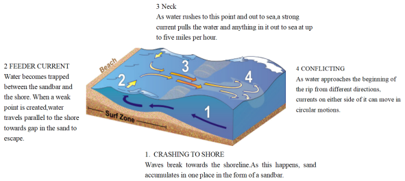
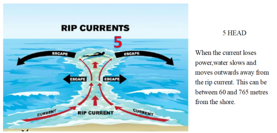
3 . WHAT ARE RIP CURRENTS?
Rip currents are like the rivers of the sea, transporting water near the shore back out into the ocean depths. The presence of these currents can be hidden by the wild movements of the surrounding waves. This means that as well as carrying seaweed and pieces of materials quickly out to sea, they can rapidly sweep away even the strongest swimmers. Around 80 percent of all lifeguard rescues are caused by powerful rip currents pulling a swimmer into danger.
If you find yourself being pulled out to sea by an unsuspected rip current, you should remain calm, focus on staying afloat and, if you can, swim parallel to the shore. Your instincts might tell you to swim towards land, as this is where you’re aiming to get to, but the current will be too strong to swim against. Instead, aim to move across the current and into slower flowing water next to it. A rip current may only pull you just past the breaking waves, but in some cases they can take you hundreds of metres offshore. The strength of currents can be hard to predict, so it’s safest to stay on lifeguarded beaches and not to swim if you see any indication of a rip current.
| A.prevent you from swimming into danger | B.transport water out into the ocean depths |
| C.clear away seaweed and pieces of materials | D.warn lifeguards against rescue in rip currents |
| A.difference between various currents | B.two types of zones off shore |
| C.an ideal route to surf in safety | D.how rip currents form |
| A.1000 metres off the shore beyond “HEAD”. | B.The channel through the gap in a sandbar. |
| C.The location where a red flag is erected. | D.Over the narrow stretch of a sandbar. |
4 . A volcanic eruption created a new but possibly changeable island in the middle of the South Pacific Ocean. An underwater volcano next to the Kingdom of Tonga erupted in early September, causing lava (岩浆) to rise to the surface. The steam (蒸汽) and water out of it then formed into a new land mass, measuring at over eight acres.
The Home Reef seamount is the place where the volcano erupted on September 10th, 2022. NASA’s Earth Observatory noted that it took about eleven hours for the land mass to rise out of the water. The agency published an image that has spread on social media that shows the size of the new unnamed island.
Over the weekend, the Tonga Geological Services stated the island was about 8.6 acres and measured about 50 feet above sea level. While volcanic activities continued to plague the Home Reef, only a couple of neighboring the Tonga islands were at low risk. “All sailors are, however, advised to sail beyond 4 kilometers away from Home Reef until further notice,” officials with the Tonga Geological Services noted in a statement.
Underwater volcanic eruptions near Tonga that led to new islands, although uncommon, have happened a few times over the last two centuries, including in 1852, 1857, 1984 and 2006. However, NASA’s Earth Observatory showed that many of these volcanic islands existed only for a few months or years.
“Islands created by undersea volcanoes often last only for a short time, though very few sometimes last for years. Home Reef has had four recorded periods of eruptions, including events in 1852 and 1857,” the agency noted. “An island created by a 12-day eruption from nearby Late’iki volcano in 2020 was washed away after two months, while an earlier island created in 1995 by the same volcano remained for 25 years.”
1. What’s the main idea of Paragraph 1?| A.How the lava rose to the surface. |
| B.How an unnamed island formed. |
| C.Why an unnamed island disappeared. |
| D.Why an underwater volcano erupted. |
| A.Change. | B.Improve. | C.Measure. | D.Trouble. |
| A.Short-lived. | B.Common. | C.Fast-growing. | D.Huge. |
| A.Tonga Islands Are at Risk |
| B.NASA Made New Discoveries in the Pacific |
| C.Underwater Volcano Creates New Island in the Pacific |
| D.Volcanic Eruption Ruins Neighboring Tonga Islands |
5 . The popular documentary series Aerial China (航拍中国) recently returned to the small screen. The latest and fourth season of it gives a perspective that is both excellent and informative. As the final of the series, the new season was shot across 11 provincial-level regions and started in the spring of 2020.
“The experience from the previous three seasons makes us more capable to follow wild animals while avoiding disturbing them,” says Yu, chief director of the series. China has made great efforts to protect endangered wildlife species and their habitats in recent years, and it has become much easier to spot rare species in the wild. Taking Tibetan antelopes as an example, the plateau-based creatures were difficult to encounter in the past, but the expansion of their population and enhanced research on their living patterns have allowed the camera crew to tailor plans to follow the animals.
Most close-ups for the season were shot by photographers from helicopters or cameras installed on drones (无人机). The vital moment for a successful shot depends on the mood of the animals or how good the weather is,” Yu says. In an attempt to fully show China’s huge changes over the past decade, the documentary series consulted experts from different fields to help select the most attractive shooting sites. In the final season, Aerial China has used 73 helicopters and 320 drones to shoot footage over an area of 900,000 kilometers, and selected around 1,000 staffers. More than 30 teams were assigned to shoot in different cities for the fourth season.
The previous three seasons have been watched by 850 million TV viewers and seen online over140 million times. For fans of the series, the director says he hopes that the new season will draw a bigger audience with its unusual perspective to show them China like never seen before.
1. Which can best replace the underlined word “perspective” in the first paragraph?| A.Reference. | B.Viewpoint. | C.Mention. | D.Standard. |
| A.To indicate a successful encounter. | B.To introduce new living patterns. |
| C.To show a biological improvement, | D.To save endangered wildlife species. |
| A.The team members’ roles. | B.The splendid shooting sites. |
| C.The hi-tech devices for shooting. | D.The efforts spent in the season. |
| A.This is the last but one season. | B.This season is well worth viewing. |
| C.The series is popular with TV reviewers. | D.The series is intended for Chinese fans. |
6 . The Best Caves in The World
Hang Son Doong, Vietnam
Natural caves don’t come much larger than Hang Son Doong, close to the border between Laos and Vietnam. This cave possesses the largest cross-section of any known cave on the planet, a vast area that is difficult to describe. Supposedly, a Boeing 747 could fly through without damaging its wings, but that doesn’t really do justice to the vastness of Hang Son Doong. The stalactites (钟乳石) here are pretty massive too, with some reaching up to 80 metres.
Waitomo Caves, New Zealand
Glowworms (萤火虫) are there, as far as the eye can see. Okay, not literally, but the Waitomo Cave system on New Zealand’s North Island is best-known for the fluorescent fauna that light up the walls, giving it the not-particularly-creative but completely acceptable “Glowworm Caves” nickname. They are more accessible than other caves on this list, with rafting and adventure tours available to those looking for something a little more thrilling.
Mammoth Cave, the USA
If you have certain expectations from somewhere called “Mammoth Cave”, that is entirely understandable. Mammoth Cave in Kentucky is the world’s longest known cave system, an incredible 420 miles of underground wonder. That’s twice as long as the next longest, by the way, although it isn’t unusual for the USA to go all out on such things.
Reed Flute (芦笛) Cave, China
Named after the reeds that grow outside, which are used to make flutes, obviously, the Reed Flute Cave’s walls are covered with inscriptions from centuries gone by—if evidence was needed that people have been paying attention to this place for a long old time. The inside part of the cave is also lit up by multicoloured lights, giving it a real otherworldly theme that adds weight to the nickname.
1. What is special about Hang Son Doong?| A.It was once a base of a factory. |
| B.It is the deepest cave in the world. |
| C.It has the highest stalactites in the world. |
| D.It owns the largest cross-section in the world. |
| A.Hang Son Doong. | B.Waitomo Caves. |
| C.Mammoth Cave. | D.Reed Flute Cave. |
| A.Vietnam. | B.New Zealand. | C.The USA. | D.China. |
7 . For those who have been wishing for real-life chocolate mountains, your dream is about to come true! Just kidding. The chocolate look-alike mounds (土丘) in Bohol, Philippines have absolutely nothing to do with chocolate aside from the fact that during one particular time of the year, they appear to look similar to chocolate.
During the wet season and anytime outside of the dry season, the Chocolate Hills maintain a green color. What attracts people’s attention is the shape of these mounds, as they look as though they were placed there by design, but none of these fields are man-made.
With regard to the origin of the Chocolate Hills, while experts have their own opinions, it’s the Filipinos who have drawn their own conclusion about the Chocolate Hills. According to a popular legend, these hills were a result of two giants (巨人) who ended up throwing mounds of earth at one another during a heated argument. As the fight heated up, they began throwing things such as rocks and sand, which is said to be what created the surrounding area. While some locals believe the legend and some don’t, it is an interesting story nevertheless and fun to think about.
However, the real story lies in the composition (成分) of the hills and this is where experts have a bit more of a scientific reason for the hills being there than just giants. With the help of heavy rainfall and erosion (侵蚀), it’s believed that limestone (石岩) was broken down over time and it’s this dissolution (分解) that created the Chocolate Hills.
The dry season in the Philippines is the only time to see these hills in all their chocolatey glory, and that falls between late November and May. However, since it is just the predicted dry season, it’s recommended that visitors check the weather before planning anything.
1. What is the color of the Chocolate Hills in the wet season?| A.Yellow. | B.Green. | C.Brown. | D.Grey. |
| A.A legend about the Chocolate Hills. |
| B.Locals’ opinions about the Chocolate Hills. |
| C.Who created the Chocolate Hills. |
| D.What the Chocolate Hills are made up. |
| A.the dissolution of limestone | B.the lack of rainfall |
| C.human activities | D.the extreme dry climate |
| A.Early November. | B.Mid-July. |
| C.Late September. | D.Early January. |
8 . ●Cliffs of Moher, Ireland
Stretching for five miles along Ireland’s western coast, the Cliffs of Moher are a sight more than 300 million years in the making. At their highest, the cliffs soar an impressive 702 feet above the Atlantic Ocean, offering millions of visitors who visit each year unbelievable views sure to leave hearts racing both from the beauty and the height.
●White Cliffs of Dover, the UK
These famous cliffs along England’s southeastern coast are as rich in history as they are in beauty. They stand tall along the Strait of Dover, separating England from France and continental Europe. During World War Ⅰ, the first bomb to hit the UK fell in Dover, and it served as an essential location during WWⅡ as well. And nowadays, the city is best known for the beauty of its white cliffs.
●Mount Thor, Canada
The name Mount Thor may inspire fear or respect — as well it should, considering this is the steepest, tallest cliff in the world. Mount Thor reaches an astonishing 4,101 feet above sea level, and the utter greatness of its vertical incline keeps it from being successfully climbed up until 1965. Today, it remains a challenging and popular place for rock climbers.
●Cliffs of Étretat, France
Located along France’s Alabaster Coast, these cliffs offer more than just steep walls. Climb to the top and you’ll have views of arched rock formations, as well as the scenery that inspired the famous painter Claude Monet. At various points along the cliffs’ 80-mile stretch, you can spot natural sculptures that are said to resemble (像) an elephant among other things.
1. What is the purpose of the author?| A.To introduce some of the world’s most amazing cliff views. |
| B.To advise people to climb cliffs in their spare time. |
| C.To ask people to explore why the cliffs are so steep. |
| D.To call on people to protect our environment. |
| A.Cliffs of Étretat. | B.White Cliffs of Dover. |
| C.Cliffs of Moher. | D.Mount Thor. |
| A.Sculptures are commonly seen along most cliffs. |
| B.Mount Thor soars amazing 702 feet above sea level. |
| C.Visitors to White Cliffs of Dover are impressed by their history. |
| D.Claude Monet got his inspiration partly from White Cliffs of Dover. |
9 . Many people assume Egypt is, and always has been, a desert. But considering that climates and landscapes can change over time and that humans have been known to change natural environments, was ancient Egypt a desert?
The simple answer is no. Not all of Egypt, ancient or modern, qualifies as a desert. Areas near the Nile River tend to be lusher (草木繁茂的), and Egyptians — in both ancient and modern times — have had a successful system of agriculture. However, the environment has changed over Egypt’s history, and the construction of the Aswan High Dam (坝) across the Nile between 1960 and 1970 changed the landscape greatly.
Some areas of Egypt that are now desert were wetter in the past. One famous example is the “Cave of Swimmers” in southwestern Egypt. Today, the area is very dry, but thousands of years ago, it was wetter, and some of the rock art found in caves in the area appears to show people swimming, according to the British Museum.
The Aswan High Dam caused some areas in southern Egypt to flood, leading to the creation of Lake Nasser. Many people had to move, and some archaeological (考古的) sites ended up underwater. The construction of the dam also ended the natural flooding of the Nile. The creation of Lake Nasser also led to more moisture (水分) in the air in some areas of southern Egypt.
One effect of the generally higher Nile River levels during the Bronze Age is that around 2500 B. C., when the pyramids at Giza were constructed, the “Khufu branch”, a vanished (消失的) branch of the Nile River, came right next to the pyramids (金字塔). This branch allowed for materials to be transported to the site by boat, aiding in pyramid construction.
The ancient Egyptians who lived by the Nile in some ways viewed themselves as living on an island in the Nile Valley, with the deserts as a sort of great sea.
1. What can we know about “Cave of Swimmers”?| A.It used to be very dry. | B.The rock art shows it used to be wet. |
| C.It’s near the British Museum. | D.It shows ancient Egyptians loved art. |
| A.It saves some Egypt archaeological sites. |
| B.It brings in too much trouble for Egyptians. |
| C.It affects Egypt both positively and negatively. |
| D.It leads to more moisture in the air in the whole Egypt. |
| A.By making Nile River water level higher. |
| B.By helping people build pyramids more easily. |
| C.By making ancient Egyptians live on an island. |
| D.By leading some branches of the Nile River disappear. |
| A.Was Ancient Egypt a Desert? | B.Do You Know Deserts in Egypt? |
| C.Was Egypt a Great Country? | D.Do You Know Ancient Egypt? |
10 . The sunrises over the Cordillera mountain ranges in the Philippines, lighting up the beautiful terraced rice fields. Rows of terraces(梯田) wraparound the mountainsides from the ground to the very mountaintops, as far as the eye can see. Built with stonewalls at least 1, 000 years old, possibly 2, 000years, they are maintained by the ancient tradition and the lifestyle of the local Ifugao people. However, with the development of economy, life here is changing. And with it comes threats to this World Heritage(遗产) Site.
Young people are influenced by modern media and no longer want to work such long hours. More educational opportunities mean that many choose to make a life outside of the villages and rice fields. Roads are being built, allowing trucks bearing agricultural goods and buses bringing more tourists to and from. More tourists mean the need for more water and food, and the production of more waste and pollution. Ugly tall buildings, rather than beautiful traditional wooden homes, spring up in some villages.
Can these changes be managed so that the terraces continue to produce rice, and remain a beautiful part of our world heritage? Jimmy Padchanan, an official of the village of Mayoyao, said in an interview, “We are combining the old societies with the new, while maintaining many of our values.” He and the local people were confident that they would keep the best of the new and the strength of the past to protect the terraces, which are described as “a living cultural landscape of breathtaking beauty”. They said cultural heritages are very valuable for human, and it is a necessary duty for everyone to try his/her best to protect them.
1. What do we know about the Cordillera terraces from the first paragraph?| A.They are often lit up at night. |
| B.They are maintained in old ways. |
| C.They are built at the foot of the mountain. |
| D.They are covered with various crops. |
| A.Media pay too much attention. | B.Agricultural land is largely taken up. |
| C.Villagers cause safety concerns. | D.Many youths left the area. |
| A.Have a mix of old and new. | B.Open our mind to new ideas. |
| C.Stop the modernization of the region. | D.Involve more development in the area. |
| A.Disappointed. | B.Worried. | C.Hopeful. | D.Sorry. |


