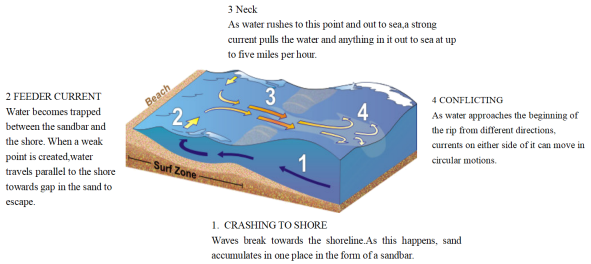
1 . WHAT ARE RIP CURRENTS?
Rip currents are like the rivers of the sea, transporting water near the shore back out into the ocean depths. The presence of these currents can be hidden by the wild movements of the surrounding waves. This means that as well as carrying seaweed and pieces of materials quickly out to sea, they can rapidly sweep away even the strongest swimmers. Around 80 percent of all lifeguard rescues are caused by powerful rip currents pulling a swimmer into danger.
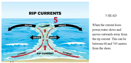
If you find yourself being pulled out to sea by an unsuspected rip current, you should remain calm, focus on staying afloat and, if you can, swim parallel to the shore. Your instincts might tell you to swim towards land, as this is where you’re aiming to get to, but the current will be too strong to swim against. Instead, aim to move across the current and into slower flowing water next to it. A rip current may only pull you just past the breaking waves, but in some cases they can take you hundreds of metres offshore. The strength of currents can be hard to predict, so it’s safest to stay on lifeguarded beaches and not to swim if you see any indication of a rip current.
| A.prevent you from swimming into danger | B.transport water out into the ocean depths |
| C.clear away seaweed and pieces of materials | D.warn lifeguards against rescue in rip currents |
| A.difference between various currents | B.two types of zones off shore |
| C.an ideal route to surf in safety | D.how rip currents form |
| A.1000 metres off the shore beyond “HEAD”. | B.The channel through the gap in a sandbar. |
| C.The location where a red flag is erected. | D.Over the narrow stretch of a sandbar. |
2 . The popular documentary series Aerial China (航拍中国) recently returned to the small screen. The latest and fourth season of it gives a perspective that is both excellent and informative. As the final of the series, the new season was shot across 11 provincial-level regions and started in the spring of 2020.
“The experience from the previous three seasons makes us more capable to follow wild animals while avoiding disturbing them,” says Yu, chief director of the series. China has made great efforts to protect endangered wildlife species and their habitats in recent years, and it has become much easier to spot rare species in the wild. Taking Tibetan antelopes as an example, the plateau-based creatures were difficult to encounter in the past, but the expansion of their population and enhanced research on their living patterns have allowed the camera crew to tailor plans to follow the animals.
Most close-ups for the season were shot by photographers from helicopters or cameras installed on drones (无人机). The vital moment for a successful shot depends on the mood of the animals or how good the weather is,” Yu says. In an attempt to fully show China’s huge changes over the past decade, the documentary series consulted experts from different fields to help select the most attractive shooting sites. In the final season, Aerial China has used 73 helicopters and 320 drones to shoot footage over an area of 900,000 kilometers, and selected around 1,000 staffers. More than 30 teams were assigned to shoot in different cities for the fourth season.
The previous three seasons have been watched by 850 million TV viewers and seen online over140 million times. For fans of the series, the director says he hopes that the new season will draw a bigger audience with its unusual perspective to show them China like never seen before.
1. Which can best replace the underlined word “perspective” in the first paragraph?| A.Reference. | B.Viewpoint. | C.Mention. | D.Standard. |
| A.To indicate a successful encounter. | B.To introduce new living patterns. |
| C.To show a biological improvement, | D.To save endangered wildlife species. |
| A.The team members’ roles. | B.The splendid shooting sites. |
| C.The hi-tech devices for shooting. | D.The efforts spent in the season. |
| A.This is the last but one season. | B.This season is well worth viewing. |
| C.The series is popular with TV reviewers. | D.The series is intended for Chinese fans. |
3 . The Best Caves in The World
Hang Son Doong, Vietnam
Natural caves don’t come much larger than Hang Son Doong, close to the border between Laos and Vietnam. This cave possesses the largest cross-section of any known cave on the planet, a vast area that is difficult to describe. Supposedly, a Boeing 747 could fly through without damaging its wings, but that doesn’t really do justice to the vastness of Hang Son Doong. The stalactites (钟乳石) here are pretty massive too, with some reaching up to 80 metres.
Waitomo Caves, New Zealand
Glowworms (萤火虫) are there, as far as the eye can see. Okay, not literally, but the Waitomo Cave system on New Zealand’s North Island is best-known for the fluorescent fauna that light up the walls, giving it the not-particularly-creative but completely acceptable “Glowworm Caves” nickname. They are more accessible than other caves on this list, with rafting and adventure tours available to those looking for something a little more thrilling.
Mammoth Cave, the USA
If you have certain expectations from somewhere called “Mammoth Cave”, that is entirely understandable. Mammoth Cave in Kentucky is the world’s longest known cave system, an incredible 420 miles of underground wonder. That’s twice as long as the next longest, by the way, although it isn’t unusual for the USA to go all out on such things.
Reed Flute (芦笛) Cave, China
Named after the reeds that grow outside, which are used to make flutes, obviously, the Reed Flute Cave’s walls are covered with inscriptions from centuries gone by—if evidence was needed that people have been paying attention to this place for a long old time. The inside part of the cave is also lit up by multicoloured lights, giving it a real otherworldly theme that adds weight to the nickname.
1. What is special about Hang Son Doong?| A.It was once a base of a factory. |
| B.It is the deepest cave in the world. |
| C.It has the highest stalactites in the world. |
| D.It owns the largest cross-section in the world. |
| A.Hang Son Doong. | B.Waitomo Caves. |
| C.Mammoth Cave. | D.Reed Flute Cave. |
| A.Vietnam. | B.New Zealand. | C.The USA. | D.China. |
4 . For those who have been wishing for real-life chocolate mountains, your dream is about to come true! Just kidding. The chocolate look-alike mounds (土丘) in Bohol, Philippines have absolutely nothing to do with chocolate aside from the fact that during one particular time of the year, they appear to look similar to chocolate.
During the wet season and anytime outside of the dry season, the Chocolate Hills maintain a green color. What attracts people’s attention is the shape of these mounds, as they look as though they were placed there by design, but none of these fields are man-made.
With regard to the origin of the Chocolate Hills, while experts have their own opinions, it’s the Filipinos who have drawn their own conclusion about the Chocolate Hills. According to a popular legend, these hills were a result of two giants (巨人) who ended up throwing mounds of earth at one another during a heated argument. As the fight heated up, they began throwing things such as rocks and sand, which is said to be what created the surrounding area. While some locals believe the legend and some don’t, it is an interesting story nevertheless and fun to think about.
However, the real story lies in the composition (成分) of the hills and this is where experts have a bit more of a scientific reason for the hills being there than just giants. With the help of heavy rainfall and erosion (侵蚀), it’s believed that limestone (石岩) was broken down over time and it’s this dissolution (分解) that created the Chocolate Hills.
The dry season in the Philippines is the only time to see these hills in all their chocolatey glory, and that falls between late November and May. However, since it is just the predicted dry season, it’s recommended that visitors check the weather before planning anything.
1. What is the color of the Chocolate Hills in the wet season?| A.Yellow. | B.Green. | C.Brown. | D.Grey. |
| A.A legend about the Chocolate Hills. |
| B.Locals’ opinions about the Chocolate Hills. |
| C.Who created the Chocolate Hills. |
| D.What the Chocolate Hills are made up. |
| A.the dissolution of limestone | B.the lack of rainfall |
| C.human activities | D.the extreme dry climate |
| A.Early November. | B.Mid-July. |
| C.Late September. | D.Early January. |
5 . Many people assume Egypt is, and always has been, a desert. But considering that climates and landscapes can change over time and that humans have been known to change natural environments, was ancient Egypt a desert?
The simple answer is no. Not all of Egypt, ancient or modern, qualifies as a desert. Areas near the Nile River tend to be lusher (草木繁茂的), and Egyptians — in both ancient and modern times — have had a successful system of agriculture. However, the environment has changed over Egypt’s history, and the construction of the Aswan High Dam (坝) across the Nile between 1960 and 1970 changed the landscape greatly.
Some areas of Egypt that are now desert were wetter in the past. One famous example is the “Cave of Swimmers” in southwestern Egypt. Today, the area is very dry, but thousands of years ago, it was wetter, and some of the rock art found in caves in the area appears to show people swimming, according to the British Museum.
The Aswan High Dam caused some areas in southern Egypt to flood, leading to the creation of Lake Nasser. Many people had to move, and some archaeological (考古的) sites ended up underwater. The construction of the dam also ended the natural flooding of the Nile. The creation of Lake Nasser also led to more moisture (水分) in the air in some areas of southern Egypt.
One effect of the generally higher Nile River levels during the Bronze Age is that around 2500 B. C., when the pyramids at Giza were constructed, the “Khufu branch”, a vanished (消失的) branch of the Nile River, came right next to the pyramids (金字塔). This branch allowed for materials to be transported to the site by boat, aiding in pyramid construction.
The ancient Egyptians who lived by the Nile in some ways viewed themselves as living on an island in the Nile Valley, with the deserts as a sort of great sea.
1. What can we know about “Cave of Swimmers”?| A.It used to be very dry. | B.The rock art shows it used to be wet. |
| C.It’s near the British Museum. | D.It shows ancient Egyptians loved art. |
| A.It saves some Egypt archaeological sites. |
| B.It brings in too much trouble for Egyptians. |
| C.It affects Egypt both positively and negatively. |
| D.It leads to more moisture in the air in the whole Egypt. |
| A.By making Nile River water level higher. |
| B.By helping people build pyramids more easily. |
| C.By making ancient Egyptians live on an island. |
| D.By leading some branches of the Nile River disappear. |
| A.Was Ancient Egypt a Desert? | B.Do You Know Deserts in Egypt? |
| C.Was Egypt a Great Country? | D.Do You Know Ancient Egypt? |
6 . Wildfire, or wildland fire, is the uncontrolled fire occurring in a forest, grassland or bushlands.
Fire danger in a wildland setting varies with weather conditions: drought, heat, and wind. Once a fire is burning, drought, heat, and wind all increase its intensity. Topography(地形) also affects wildfire, which spreads quickly uphill and slowly downhill. Dried grass, leaves, and light branches are considered flash fuels, and fire spreads quickly in them, often generating enough heat to burn heavier fuels such as tree stumps(树桩), heavy branches, and the organic matter of the forest floor. Such fuels, ordinarily slow to burn, are difficult to extinguish. Green fuels—growing vegetation-are not considered to catch fire easily, but an intense fire can dry out leaves and needles quickly enough to allow ready burning. Green fuels sometimes carry a special danger. Evergreens, such as pine and spruce(云杉), contain oils that easily burst into flames when heated sufficiently by the searing drafts(灼热的气流) of a forest fire.
Firefighting forces are specially trained to deal with wildfires. Aircraft were first used in fighting wildland fires in 1919. Now airplanes and helicopters are primarily used for dumping water, for observation, and occasionally for assisting in communication and transporting personnel, supplies, and equipment
Tools for fighting wildfires range from the standard equipment of urban fire departments to portable pumps, tank trucks, and earth-moving equipment. It can also change the fire’s direction as well as slowing its progress. They are maintained by public and private owners of forestlands. Such a force may attack a fire directly by spraying water, beating out flames, and removing vegetation at the edge of the fire to contain it behind a fire line. When the very edge is too hot to approach, a fire line is built at a safe distance, sometimes using strip (长条地带) burning to get rid of the fuel in the path of the uncontrolled fire.
1. What is Paragraph 2 mainly about?| A.What causes wildfire to happen. |
| B.How topography affects wildfire intensity. |
| C.Why wildfire danger hides in green fuels. |
| D.Where wildfire often breaks out. |
| A.Carrying thin leaves. A. When the fire dies down. |
| B.Having heavy branches. |
| C.Lacking enough water. |
| D.Containing some oil. |
| A.When the fire dies down. |
| B.When the wind blows hard. |
| C.When the fuel burns uncontrollably. |
| D.When the pump works effectively. |
| A.An advertisement brochure. |
| B.A news report. |
| C.A sci-fi lecture, |
| D.A geography magazine. |
7 . The US government has recently helped people learn more about the dangers of earthquakes by publishing a map. This map shows the chances of an earthquake in catch part of the country. The areas of the map where earthquakes are most likely to occur are called earthquake belts. The government is spending a great deal of money and is working hard to help to discover the answers to these two questions:
Can we predict earthquakes?
Can we control earthquakes?
To answer the first question, scientists are looking very closely at the most active fault (断层) systems in the country, such as the San Andreas fault in California. A fault is a break between two sections of the earth’s surface. These breaks between sections are the places where earthquakes occur. But it will probably be many years before we can predict earthquakes correctly. And the control of earthquakes is even farther away.
However there have been some interesting developments in the field of controlling earthquakes. The most interesting development concerns the Rocky Mountain Arsenal earthquakes. Here water was put into a layer of rocks 4,000 metres below the surface of the ground. Shortly after this injection (注射) of water, there was a small number of earthquakes. Scientists have decided that the water which was injected into the rocks worked like oil on each other.
When the water “oiled” the fault, the fault became slippery and the energy of an earthquake was given out. Scientists are still experimenting at the site of these earthquakes. They have realized that there is a connection between the injection of the water and the earthquake activity. They have suggested that it might be possible to use this knowledge to prevent very big, dangerous earthquakes, that is, scientists could inject some kind of fluid like water into faults and change on a big earthquake into a number of small, harmless earthquakes.
1. Earthquakes belts are .| A.maps that show where earthquakes are likely to occur |
| B.zones with a high probability of earthquakes |
| C.breaks between two sections of the earth's surface |
| D.the two layers of earth along a fault |
| A.an active fault system |
| B.a place where earthquakes have been predicted correctly |
| C.a place where earthquakes have been controlled |
| D.at the foot of the Rocky Mountain |
| A.They occur at about 4.000 metres belowground level |
| B.The injection of water into earthquake faults prevent earthquakes from occurring. |
| C.They are usually caused by the oil in the faults. |
| D.Harmful earthquakes could be prevented by causing harmless earthquakes. |
| A.They have no practical value in earthquake prevention. |
| B.They may have practical value in earthquake prevention. |
| C.They are certain to have practical value in earthquake prevention. |
| D.Nothing is told about their practical value in earthquake prevention. |


