1 . About one million years ago, the Ice Age began. The Ice Age was a long period of time in which four great glaciers (冰川) pushed southward to cover almost all the upper half of North America, and then melted away. Each glacier was a thick sheet of ice and snow that spread out from a center near what is now Hudson Bay in Canada. The winters were long, and the cool summers were too short to melt much of the ice and snow, The ever - growing sheet built up to a thickness of two miles at its center.
As all glaciers do, these great glaciers slid. They pushed down giant trees in their paths and scraped (刮, 削) the earth bare of soil. Many animals moved farther south to escape. Others stayed and were destroyed.
When winters of little snow came, the summer suns shone into the edges to the ice sheets. As the glaciers melted, rocks, soil and other things that had mixed with the ice and snow were left. New hills, lakes and rivers were formed.
The last of the great glaciers began its melting about 11000 years ago. Its melting formed the Great Lakes. These lakes are today little changed from their early sizes and shapes. The largest of the North American river systems Was also influenced by the glaciers. This is the Mississippi - Missouri - Ohio system. These rivers were miles wide a first. Through the years they settle into their present channels.
1. The main idea of this passage is ________ .| A.the Ice Age was a long period of time |
| B.great glaciers covered North America many years ago |
| C.changes in climate helped to melt the glaciers |
| D.how glaciers changed North America |
| A.are two miles thick | B.form frozen lakes |
| C.are a million years old | D.move and slide |
| A.the sliding of glaciers are usually destructive |
| B.all glaciers in the world move southward |
| C.the Mississippi - Missouri - Ohio system is larger than it was before the ice Age |
| D.the Great Lakes are now smaller than they were before the ice Age |
| A.lakes | B.rivers | C.glaciers | D.systems |
1. Where is the island?
| A.It is in Asia. |
| B.It is in the Pacific Ocean. |
| C.It is off the coast of Europe. |
| A.It’s free of pollution. | B.It’s not far away. | C.It’s small. |
| A.Beautiful. | B.Wild. | C.Unusual. |
| A.Eight. | B.Seven. | C.Six. |
Now rewind this picture 1,839 years. You are in the same seat, only you are watching classical Greek entertainment.
The city of Athens is a fun mix of the old and the new, the classic and the modern. Often a little shop is located next to the ruins of a temple, which is only a block from a large, air-conditioned hotel. The great city of 2,500 years ago is still visible today.
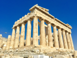
Ruins are the most obvious sign of ancient Athens, and the most famous of these is the Acropolis(卫城). The Acropolis is a large hill that was the center of life in Athens. On its slopes were temples, monuments, and theaters. From the top, you can see how the urban area of Athens stretches out in every direction.
On the top of the Acropolis is the Parthenon. This was once a huge temple to Athena, the city’s patron. It was first completed in 432 B.C., but has been damaged and destroyed several times. However, visitors can still see the “tricks” used in building the Parthenon. The columns along the outside lean inward, and are slightly fatter in the middle. The temple is also higher in the middle than on the sides. All these effects make the Parthenon look perfectly straight from a distance.
Only a block away from the Acropolis is the neighborhood of Plaka. The area, with its little shops and restaurants, is very popular with both tourists and locals, and is an important part of modern Athenian culture. Many great thinkers, writers, and political leaders lived in ancient Athens. The ruins of their homes and favorite spots are scattered throughout the busy port city. The hill where St. Paul addressed early Christian Athenians is located near the Acropolis. Great thinkers such as Perikles and Demosthenes spoke to the civil assemblies held at the Pnyx Hill. Today the Pnyx is an open-air theater for light and sound shows.
Tourism is very important to people who live in modern-day Athens. Thousands of people come every year to see these ruins and to tour the many museums that house artifacts from ancient times. This provides many jobs and brings money into Athens, which helps the city pay for improvements. Athenians take pride in the accomplishments of their ancestors, and people from all around the world come to admire them. By looking around the city today, we can imagine what life was like in ancient Athens.
1. Which of the following statements is INCORRECT about the city of Athens?| A.The culture of the city is a mixture of the old and modern. |
| B.Traces of the ancient city can still be found |
| C.Ruins and modern hotels co-exist in the city. |
| D.All the temples are not far away from air-conditioned hotels. |
| A.naughty acts | B.confusing constructing skills |
| C.skillful constructing methods | D.constructing materials |
| A.offering job opportunities to Athenians |
| B.enriching Athenians by providing accommodation for tourists |
| C.enabling Athenians to improve the infrastructures |
| D.making Athenians proud of their ancestors |
| A.Tourism in Athens | B.Athens: Then and Now |
| C.Historic Interests in Athens | D.The Magic of Ancient Athens |
4 . If you live in a town or city on the edge of a desert or coastline where sand dunes form, you might understand the threat they can have. It’s, sometimes, a piece of cake for them to cover roads, buildings, farms and other man-made developments with their unpredictable movements. Thus, figuring out how they move is important for preventing some natural disasters.
Now scientists have discovered that dunes have been secretly moving in ways we never knew before. There are different explanations on dune interaction, however, Karol Bacik, first author on the new dune study, and his colleagues have found a new one for dune movement. The researchers employed high-speed cameras to observe how dunes separated by distance can act as if they’re connected.
It turns out, currents flowing over sand dunes can carry “information” to other dunes downstream in the form of swirls(旋涡). For instance, as wind or water flows over the top of a dune, it slightly moves. This can generate “swirls” on the back of a downstream dune and push it in a direction opposite the movement of the front dune.
It’s the first time that researchers were able to provide causal explanations for some of these strange, previously unpredictable movements. The team also hopes to get out of the laboratory and into the real world, to see if their models can be applied to dune movements in complex natural systems. They plan to use satellite images over large deserts to track groups of dunes over long periods.
Perhaps they can start to alter the dune marching orders in the near future. Imagine being able to tell a dune field exactly how you want it to move. That’s the idea that this research might one day make possible.
1. We can learn that the purpose of the study is to _________.| A.stop the sand dunes from moving around |
| B.figure out the track of sand dune movements |
| C.prove the interaction of dunes with each other |
| D.examine a model of sand dunes in the real world |
| A.A study. | B.An interaction. | C.An explanation. | D.A dune. |
| A.A sand dune communicates with another only by currents. |
| B.Swirls on the back of a dune are the power to move itself. |
| C.Some strange dune movements have got causally explained before. |
| D.Researchers think it unnecessary to study further on the dune models. |
5 . In the middle of the Pacific Ocean lies the tiny island nation of Tuvalu,the fourth smallest country in the world. This group of four islands and five atolls (islands made from coral) is famous for its sandy beaches and turquoise (蓝绿色的) waters and has long been a popular tourist destination for nearby New Zealanders. However, the nation of Tuvalu is at risk of soon no longer existing; not because of war or political change, but because it will be covered by the rising ocean.
Tuvalu is experiencing the harmful effects of global warming. As global temperatures rise, so does the ocean temperature. Due to the scientific law of “thermal expansion,” when water heats it get bigger.
Even before Tuvaluans began to suffer from the effects of climate change, lift on Tuvalu was tough.
More serious than Tuvalu’s lack of home-grown food has been its lack of drinking water.
Tuvalu’s problems have led some of its 11, 000 inhabitants to consider migrating to Australia or New Zealand.
| A.It was a desperate situation and, but for emergency shipments from New Zealand and Australia, many Tuvaluans would have died. |
| B.This is largely due to the geological makeup of atolls. |
| C.Unlike normal islands, atolls have no rivers or streams, which means that most of Tuvalu has no groundwater to use for drinking. |
| D.Tuvalu’s representatives demanded that nations should take a more responsible rote in reducing gas emissions. |
| E.Therefore, sea levels are rising and for low-lying Tuvalu, this spells disaster. |
| F.However, they ate not willing to abandon the land of their forefathers so easily. |
| G.And as a member of the United Nations, they are doing just that. |
6 . Ship tourism to Antarctica is on the rise: More than 35,000 tourists are expected to visit Antarctic this summer. In 1992-1993, 6,750 visited Antarctica, according to the Antarctica Treaty. All of this tourism, however, is putting both tourists and the environment in great danger.
Among the tourist ships that visit the continent, the Explorer, a Canadian ship, was one of the first. Put to use in 1969, it was built to carry tourists to Antarctica. Last week, however, it became the first commercial passenger ship to sink beneath the waters. Fortunately, all of the passengers and crew members were rescued from the ship. However, the sunken ship endangered the Antarctic’s fragile(脆弱的) environment. The ship was estimated to be holding 48,000 gallons of fuel.
The accident was not unexpected. Both the US and UK had warned a conference of the Antarctic Treaty member countries in May that the tourism situation in this area was a potential disaster. The US said in a paper, people “should take a hard look at tourism issues now, especially those related to ship safety.” Although the Antarctic seas are relatively calm, floating ice causes a potential threat to ships. The owner of the Explorer blamed the sinking on a fist-like hole in the ship created by ice.
Many of the other large ships now visiting Antarctica are not designed especially against thick ice. Such ships generally can only come to the continent in summer. But the tourist rush is pushing ships into dangerous situations. “The increasing number of ships operating in Antarctic means that the ship are under great pressure to get there in time for the key visiting sites,” the British government wrote in a paper at the meeting of member countries.
As a natural frontier, Antarctica is in a messy legal situation. There are no obvious answers as to who is responsible for dealing with the threat that tourist may cause to human life and the environment.
There is no coast guard for Antarctica. Do we want it to become Disneyland, or do we need some controls?
1. Which of the following is true according to this passage?| A.Antarctica tourism has a history of about 17 years. |
| B.The number of tourists to the Antarctic is over 5 times as large as that of 17 years ago. |
| C.The tourism boom has caused holes in the floating ice in the Antarctic. |
| D.The Antarctica Treaty is responsible for the environmental problems. |
| A.led to a conference about the tourism situation in the Antarctic. |
| B.was caused by the rough seas |
| C.had been predicted |
| D.did harm to the Antarctic. |
| A.people had better not make a tour of the Antarctic |
| B.ships to the Antarctic should be built strong enough |
| C.there should be legal controls over tourism in the Antarctic |
| D.the Antarctic’s environment is fragile to be protected |
1. How high is the Eiffel Tower?
| A.1.500 meters. | B.1,930 meters | C.1,050 meters |
| A.Copper | B.Iron | C.Stone |
| A.Taking elevators | B.Taking stairs | C.Taking ladders |
| A.Landmarks | B.Beautiful views | C.Souvenirs. |
| A. recently B. estimated C. employing D. definition E. confusing F. updated G. scientific H. argument I. depending J. distinct K. finally |
Most of us learn at primary school that there are seven continents, but the next generation of kids may be adding one more to that list.
According to a recent paper published
Zealandia is
The small country is the only part of Zealandia that isn’t underwater, but the paper’s authors want the huge landmass to be recognized worldwide as its own continent.
“The
Scientists discovered Zealandia all the way back in 1995, then started extensive research on the area
But who decides on what is a continent and what isn’t? There is, in fact, no official organization that does. Some countries’ schools teach that there are six or even five continents. This changes
Due to their
And to make things even more
This
But will the world take the same notice of Zealandia? The best way to tell is to keep an eye on our textbooks.
9 . Mapping Antarctica
Antarctica was on the map long before anyone ever laid eyes on it. Nearly 2,400 years ago, ancient Greek philosophers such as Aristotle believed that a great continent must exist at the bottom of the world. They though it was needed to balance out the continents at the top of the world. In the 1500s, mapmakers often included a fanciful continent they referred to as Terra Incognita(Latin for “unknown land”) at the bottom of their maps. But it was not until the 1800s -----after explorers had sighted and set foot on Antarctica----- that mapmakers got down to the business of really mapping the continent, which is one—and—a –half times rhe size of the U.S..
While the coastline could be mapped by ships sailing around the continent, it took airplanes—and later, satellites---to chart Antarctica’s vast interior(内陆). That job continues today. And it is a job that still require a mapmaker, or cartographer, to put on boots and head out into the wild.
Cole Kelleher is familiar with that. He is a cartographer with the Polar Geospatial Center(PGC), which is based at the University of Minnesota and has a staff at McMurdo Station. PGC teamed up with Google to use the company’s Trekker technology to capture images of Antarctica for the Internet giant’s popular feature, Street View. A Trekker camera, which is the size of a basketball, is set about two feet above a backpack. The camera records image in all directions. “It weighs about 50 pounds. I was out for two and a half days, hiking 10 to 12 hours each day,” says Kelleher. It was hard work, but really an incredible experience.” According to Kelleher there are plans to use the technology to create educational apps for museums.
The PGC staff at McMurdo Station provides highly specialized mapmaking services for the U.S. Antarctic Program. For one project, Kelleher used satellite images to map huge cracks in the ice. That helped a team of researchers know whether they could safely approach their field camp on snowmobiles. Another recent project was to help recover a giant, high—tech helium(氦气) balloon used to carry scientific instruments high into the atmosphere. These balloons are launched in Antarctica because there is no danger that they will hurt anyone when they fall back down to Earth. Using satellite images, Kelleher and colleagues created maps of where the balloon could be found.
Antarctica may no longer be Terra Incognita, but it still holds countless mysteries. Cartographers and the maps they make will continue to be essential in helping scientists unlock those secrets.
1. From the passage, we can infer that Antarctica was on the map in the 1500s when________.| A.mapmakers knew it was much larger than the U.S. |
| B.Aristotle named the continent Terra Incognita |
| C.no one had ever seen or been to the continent |
| D.it was such an interesting continent as was often referred to |
| A.It needs much work for the mapmakers to head out into the wild. |
| B.The interior can only be mapped by planes and satellites. |
| C.It is relatively easy to map Antarctica’s coastline by ship. |
| D.Antarctic is a vast but still mysterious continent. |
| A.to capture images of Antarctica for Street View |
| B.to test the company’s Trekker technology |
| C.to create educational apps for museums |
| D.to hike for an incredible experience |
| A.satellite images which are used to map huge cracks in the ice |
| B.a high-tech helium balloon for carrying scientific instruments |
| C.how to safely approach the researcher’s field camp and the balloon |
| D.the specialized mapmaking services provided by the PGC staff |
1.酒店的位置:
2. 推荐的理由;
注意: 1.词数100左右;
2.可适当增加细节, 以使行文连贯;
3.开头和结尾已为你写好,不计入总词数。
Dear Tom.
I'm more than pleased to hear
_________________________________________________________________________________________________________________________________________________________________________________________________________________________________________________________________
Yours,
Li Hua


