Now rewind this picture 1,839 years. You are in the same seat, only you are watching classical Greek entertainment.
The city of Athens is a fun mix of the old and the new, the classic and the modern. Often a little shop is located next to the ruins of a temple, which is only a block from a large, air-conditioned hotel. The great city of 2,500 years ago is still visible today.
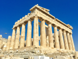
Ruins are the most obvious sign of ancient Athens, and the most famous of these is the Acropolis(卫城). The Acropolis is a large hill that was the center of life in Athens. On its slopes were temples, monuments, and theaters. From the top, you can see how the urban area of Athens stretches out in every direction.
On the top of the Acropolis is the Parthenon. This was once a huge temple to Athena, the city’s patron. It was first completed in 432 B.C., but has been damaged and destroyed several times. However, visitors can still see the “tricks” used in building the Parthenon. The columns along the outside lean inward, and are slightly fatter in the middle. The temple is also higher in the middle than on the sides. All these effects make the Parthenon look perfectly straight from a distance.
Only a block away from the Acropolis is the neighborhood of Plaka. The area, with its little shops and restaurants, is very popular with both tourists and locals, and is an important part of modern Athenian culture. Many great thinkers, writers, and political leaders lived in ancient Athens. The ruins of their homes and favorite spots are scattered throughout the busy port city. The hill where St. Paul addressed early Christian Athenians is located near the Acropolis. Great thinkers such as Perikles and Demosthenes spoke to the civil assemblies held at the Pnyx Hill. Today the Pnyx is an open-air theater for light and sound shows.
Tourism is very important to people who live in modern-day Athens. Thousands of people come every year to see these ruins and to tour the many museums that house artifacts from ancient times. This provides many jobs and brings money into Athens, which helps the city pay for improvements. Athenians take pride in the accomplishments of their ancestors, and people from all around the world come to admire them. By looking around the city today, we can imagine what life was like in ancient Athens.
1. Which of the following statements is INCORRECT about the city of Athens?| A.The culture of the city is a mixture of the old and modern. |
| B.Traces of the ancient city can still be found |
| C.Ruins and modern hotels co-exist in the city. |
| D.All the temples are not far away from air-conditioned hotels. |
| A.naughty acts | B.confusing constructing skills |
| C.skillful constructing methods | D.constructing materials |
| A.offering job opportunities to Athenians |
| B.enriching Athenians by providing accommodation for tourists |
| C.enabling Athenians to improve the infrastructures |
| D.making Athenians proud of their ancestors |
| A.Tourism in Athens | B.Athens: Then and Now |
| C.Historic Interests in Athens | D.The Magic of Ancient Athens |
2 . Lonely Planet Trips
Here are some travel destinations by Lonely Planet. Reading them, you’ll be in a flash.
Bhutan
The Kingdom of Bhutan, located on the Silk Road in South Asia, claimed the No. 1 spot partly for its majestic beauty and because it had become the first fully organic nation by 2020. The kingdom has lush subtropical plains in the south and sub-alpine Himalayan mountains in the north, which include Gangkhar Puensum, Bhutan’s highest peak and is believed to be the highest unclimbed mountain in the world.
North Macedonia
If you want an alternative to Europe's more popular travel spots, North Macedonia could be for you. Its mountains and their trails are “blissfully quiet” and the locals are “unfailingly helpful” according to Lonely Planet. Among its destinations is Ohrid, a charming, old town dotted with medieval ruins and churches, lined with cobblestone streets, and overlooking Lake Ohrid.
Eswatini
The kingdom offers multitudinous climate and topography differences, and is known for its wide varieties of wild animals, which include more than 500 bird species and 107 mammal species. The nation has seven nature reserves, four frontier conservation areas and three wildlife reserves.
Costa Rica
Costa Rica is beloved for many reasons, from its coffee to its epic surfing. It’s also notable for its reliance on green energy sources. In fact, 90% of its energy is created by regenerative sources such as wind and hydro. It is also one of the world’s most biodiverse countries — home to half a million species. Of course, no trip to Costa Rica is complete without a visit to the Sloth Sanctuary.
1. What can tourists appreciate in both Bhutan and North Macedonia?| A.Organic products. | B.Subtropical jungles. |
| C.Medieval architecture. | D.Mountain scenery. |
| A.Pleasant quietness. | B.Topography varieties. |
| C.Abundant wildlife. | D.Cobblestone streets. |
| A.Renewable resources. | B.Biodiverse plants. |
| C.Frontier preserves. | D.The Silk Road. |
3 . Rainforests are home to a rich variety of medicinal plants, food, birds and animals. Can you believe that a single bush(灌木丛)in the Amazon may have more species of ants than the whole of Britain! About 480 varieties of trees may be found in just one hectare of rainforest.
Rainforests are the lungs of the planet-storing vast quantities of carbon dioxide and producing a significant amount of the world's oxygen. Rainforests have their own perfect system for ensuring their own survival; the tall trees make a canopy(树冠层)of branches and leaves which protect themselves, smaller plants, and the forest animals from heavy rain, intense dry heat from the sun and strong winds.
Amazingly, the trees grow in such a way that their leaves and branches, although close together, never actually touch those of another tree. Scientists think this is the plants' way to prevent the spread of any tree diseases and make life more difficult for leaf-eating insects like caterpillars. To survive in the forest, animals must climb, jump or fly across the gaps. The ground floor of the forest is not all tangled leaves and bushes, like in films, but is actually fairly clear. It is where dead leaves turn into food for the trees and other forest life.
They are not called rainforests for nothing! Rainforests can generate 75%of their own rain. At least 80 inches of rain a year is normal-and in some areas there may be as much as 430 inches of rain annually. This is real rain-your umbrella may protect you in a shower, but it won't keep you dry if there is a full rainstorm. In just two hours, streams can rise ten to twenty feet. The humidity(湿气)of large rainforests contributes to the formation of rainclouds that may travel to other countries in need of rain.
1. What can we learn about rainforests from the first paragraph?| A.They produce oxygen. | B.They cover a vast area. |
| C.They are well managed. | D.They are rich in wildlife. |
| A.Heavy rains | B.Big trees. |
| C.Small plants. | D.Forest animals. |
| A.For more sunlight. | B.For more growing space. |
| C.For self-protection. | D.For the detection of insects. |
| A.Life-Giving Rainforests | B.The Law of the Jungle |
| C.Animals in the Amazon | D.Weather in Rainforests |
4 . The following are a few places recommended by tourists.
Ka’awaloa Trail
The pathway is steep and continues for about 2 miles each way, so the way there will be a lot easier than the way back. Keep in mind that the loose rocks may present a dangerous situation when slippery, so do carry the appropriate footwear and plenty of water to fight against the intense sun.
Mauna Kea Summit
Most hikers give themselves 8 to 10 hours to finish the journey. Don’t forget to register at the Mauna Kea Visitors Center before setting out, and plan on being back before sunset. The weather here is unpredictable and completely unique to the rest of the island. This area is pure wilderness, and altitude sickness is a definite risk, so researching the hike in advance on the Mauna Kea website is a must.
Waipio Valley Trail
Famed Waipio Valley, the former home of King Kamehameha, shouldn’t be missed by nature lovers. Be sure to catch a glimpse of nearby Hiilawe Falls from here, flowing 1,300 feet at the back of the valley. About 6.5 miles round-trip, this adventure will most likely be too difficult for beginner hikers due to the steep inclines(倾向) and length.
Onomea Bay Trail
Onomea Bay offers two different hikes from the Mamalahoa Highway in Papaikou. The first, the Donkey Trail, follows a stream through the Hawaiian rainforest past a small waterfall and to the ocean. The second, Onomea Trail, goes just to the right of the Hawaii Tropical Botanical Garden and past the Alakahi stream. Many choose to combine the trails or pair the hike with the botanical garden for added adventure.
1. What should tourists be careful about in Ka’awaloa Trail?| A.Burning. | B.Loose rocks. | C.Dry weather. | D.The steep pathway. |
| A.The journey lasts long. | B.There exist many tourists. |
| C.There’s a potential danger. | D.The weather is unpredictable. |
| A.They attract plant lovers. | B.Tourists can see waterfalls. |
| C.Tourists can hike along a stream. | D.They aren’t suitable for beginner hikers. |
5 . The United States has a vast network of National Parks spread all around the country. Here are some National Parks for you.
Arches National Park, Utah
More than 2,000 natural stone arches make Arches National Park a special place in Utah. Travelers from around the world come to see brilliant sunsets that light up the sky each night. Hikers and rock climbers will love the endless options for exploring, while more low-key visitors are sure to love the camping.
Acadia, Maine
Super close to Bar Harbor, one of Maine's most beloved tiny towns, Acadia National Park tops travel guides for the Vacation State. Before making your way to Mt. Desert island, dine on the country's most famous fish and lake advantage of the opportunity to go whale watching on the Atlantic Ocean. When visiting Acadia, set aside some time to hike and go boating.
Mount Rainier, Washington
We couldn't leave the park with you slowly moving ice off the list. Washington's Mount Rainier National Park, found southeast of Seattle, has 25 of them (along with the famous volcano) as its attention-catching sight. The National Park says it's "the snowiest place on earth where snow is measured regularly." If snowcapped peaks aren't your thing, plan to visit the park when the weather is warmer.
Great Sand Dunes (沙丘), Colorado
You probably imagine the Rocky Mountains when you think about Colorado, but did you know that the Centennial state is also home to the United States' largest sand dunes? See them for yourself at Great Sand Dunes National Park, where you can go sand boarding or "fat biking". Though June temperatures are said to be some of Southern Colorado's best, a warm winter day can be an equally enjoyable time to see the dunes.
1. What do Arches National Park and Acadia have in common?| A.Tourists can hike in the parks. | B.They are located in tiny towns. |
| C.Both of the parks offer sea food. | D.They offer free guide to travellers. |
| A.Sunsets. | B.Whales. |
| C.Ice. | D.Sands. |
| A.Arches National Park, Utah | B.Acadia, Maine |
| C.Mount Rainier, Washington | D.Great Sand Dunes, Colorado |
6 . “I could see a huge flow (流动) of water, coming down fast from very high. I had no idea of shape, or situation, or anything. It was just so big.”
These are the words of the great English writer Charles Dickens. He wrote them when he was visiting Niagara Falls. This waterfall is on the border (边界) of the United States and Canada. It is one of the largest in the world, and the largest in North America.
Niagara Falls is on the Niagara River. The river divides just before the waterfall, and there are actually three waterfalls. On the American side are American Falls and Bridal Veil Falls. Horseshoe Falls is mostly on the Canadian side. The name comes from its shape — like a horseshoe, in a half circle. Horseshoe Falls is the widest of the three.
People mainly know about Niagara Falls because of its size and natural beauty. However, the Niagara River is also an important source of electricity.
In the 1890s, the Westinghouse Electric Company built a large power system (电力系统) on the river. Many other companies also hoped to use the land for factories and power systems. However, around the same time, many people began to work to protect the natural area. Soon, the governments of the United States and Canada got involved with it. They protected the land around Niagara Falls. They made parks — green, natural areas. No one could buy this land for factories. For hundreds of years, millions of people have visited Niagara Falls to enjoy its beauty.
1. From Paragraph 1, we can know Charles Dickens was shocked by Niagara Falls’ __________.| A.speed | B.color |
| C.size | D.beauty |
| A.It has three waterfalls. |
| B.It’s on the Niagara River. |
| C.It’s on the border of two countries. |
| D.It’s the widest waterfall in the world. |
| A.shape | B.sound | C.history | D.location |
| A.The Niagara River is badly polluted. |
| B.There are no factories around Niagara Falls. |
| C.Visitors can learn how Niagara Falls produces electricity. |
| D.Many companies built power systems around Niagara Falls in the 1890s. |
7 . Mapping Antarctica
Antarctica was on the map long before anyone ever laid eyes on it. Nearly 2,400 years ago, ancient Greek philosophers such as Aristotle believed that a great continent must exist at the bottom of the world. They though it was needed to balance out the continents at the top of the world. In the 1500s, mapmakers often included a fanciful continent they referred to as Terra Incognita(Latin for “unknown land”) at the bottom of their maps. But it was not until the 1800s -----after explorers had sighted and set foot on Antarctica----- that mapmakers got down to the business of really mapping the continent, which is one—and—a –half times rhe size of the U.S..
While the coastline could be mapped by ships sailing around the continent, it took airplanes—and later, satellites---to chart Antarctica’s vast interior(内陆). That job continues today. And it is a job that still require a mapmaker, or cartographer, to put on boots and head out into the wild.
Cole Kelleher is familiar with that. He is a cartographer with the Polar Geospatial Center(PGC), which is based at the University of Minnesota and has a staff at McMurdo Station. PGC teamed up with Google to use the company’s Trekker technology to capture images of Antarctica for the Internet giant’s popular feature, Street View. A Trekker camera, which is the size of a basketball, is set about two feet above a backpack. The camera records image in all directions. “It weighs about 50 pounds. I was out for two and a half days, hiking 10 to 12 hours each day,” says Kelleher. It was hard work, but really an incredible experience.” According to Kelleher there are plans to use the technology to create educational apps for museums.
The PGC staff at McMurdo Station provides highly specialized mapmaking services for the U.S. Antarctic Program. For one project, Kelleher used satellite images to map huge cracks in the ice. That helped a team of researchers know whether they could safely approach their field camp on snowmobiles. Another recent project was to help recover a giant, high—tech helium(氦气) balloon used to carry scientific instruments high into the atmosphere. These balloons are launched in Antarctica because there is no danger that they will hurt anyone when they fall back down to Earth. Using satellite images, Kelleher and colleagues created maps of where the balloon could be found.
Antarctica may no longer be Terra Incognita, but it still holds countless mysteries. Cartographers and the maps they make will continue to be essential in helping scientists unlock those secrets.
1. From the passage, we can infer that Antarctica was on the map in the 1500s when________.| A.mapmakers knew it was much larger than the U.S. |
| B.Aristotle named the continent Terra Incognita |
| C.no one had ever seen or been to the continent |
| D.it was such an interesting continent as was often referred to |
| A.It needs much work for the mapmakers to head out into the wild. |
| B.The interior can only be mapped by planes and satellites. |
| C.It is relatively easy to map Antarctica’s coastline by ship. |
| D.Antarctic is a vast but still mysterious continent. |
| A.to capture images of Antarctica for Street View |
| B.to test the company’s Trekker technology |
| C.to create educational apps for museums |
| D.to hike for an incredible experience |
| A.satellite images which are used to map huge cracks in the ice |
| B.a high-tech helium balloon for carrying scientific instruments |
| C.how to safely approach the researcher’s field camp and the balloon |
| D.the specialized mapmaking services provided by the PGC staff |
8 . America's Most Beautiful Places to Visit in Spring
Washington, D.C.
Every spring, Washington, D.C.is blanketed in pink with cherry blossoms. To celebrate the event, come to the National Cherry Blossom Festival, which takes place from the last week in March to the second week in April. You can view the flowers or take part in festival events.
Charleston, South Carolina
No list of beautiful spring cities would be complete without mention of Charleston, South Carolina. Delight in hanging plants, cobblestone streets, and historical castles. And because of year-round pleasant temperatures, you might even hit a beach day in March or April.
North Cascades National Park, Washington
The North Cascades is home to everything from mountains to forests to grassland, and the scenery changes seasonally. In spring—the snow disappears to bring strong waterfalls, and wildflowers spot the land. Different areas will present totally unique plants, so give yourself a few days to take in the sights.
Central Park, New York
New York is the city that never sleeps, no matter what the season, but springtime is the best time to take a walk through Central Park. It is one of the most filmed locations in the world. A spring time promises walks past Victorian houses, a brief visit to ancient shops, and of course long walks by the lake.
1. Which is the best time to visit Washington, D.C.?| A.March 15. | B.April 1. |
| C.March 8. | D.April 28. |
| A.cherry blossoms and various celebrations |
| B.pleasant weather and historical castles |
| C.strong waterfalls and wild flowers |
| D.Victorian houses, old shops, and long walks |
| A.Central Park, New York | B.North Cascades National Park |
| C.Charleston | D.Washington, D.C. |
9 . Famous Modern Chinese Buildings
Beijing International Airport
The first place most visitors see when they arrive in China is Beijing International Airport. The airport was constructed in the 1950s. It has an indoor garden, a children’s playground, and over 70 food businesses in Terminal 3 alone.
Shanghai World Financial Center
Completed in 2008, SWFC took over 10 years to complete due to financial shortages and construction delays. Since its completion, it has won countless architectural awards.
Tourists are welcome at SWFC's viewing platform, which at 474 meters above ground is the worlds highest closed viewing platform.
The Water Cube
It was constructed for use during the Beijing 2008 Summer Olympics. Now visitors can express surprise at the architecture of the building. They can enjoy the indoor atmosphere as well.
Among the offerings of the Water Cube are a restaurant and bar, a shopping area, and Water World, a family water park
The Bird's Nest, Beijing
It was designed mainly for the 2008 Summer Olympics. It can hold up to 80,000 people and has been used for a winter theme park. Nowadays, its main income is as a tourist attraction. It draws more than 20,000 tourists every day.
National Center for the Performing Arts
It was completed in 2007. The building is surrounded by a man-made lake, requiring guests to enter via an underground hallway. It is home to an Opera Hall, Music Hall, and Theater.
1. Which of the following buildings was first constructed?| A.Beijing International Airport. | B.Shanghai World Financial Center. |
| C.The Water Cube. | D.The Birds Nest, Beijing. |
| A.It needed more construction workers. | B.It was short of money. |
| C.It added an extra viewing-platform. | D.It faced too much terrible weather. |
| A.By renting the winter theme park. | B.By increasing its opening time. |
| C.By charging tourists for admission fees. | D.By giving some live concerts. |
| A.Enjoy sports events. | B.Play musical instruments. |
| C.Attend science lectures. | D.Watch different performances. |
10 . Theaters of the Past
The Greek Theater
Theaters developed in many parts of Greece. Ancient Greek theaters were built in natural open air sites on conveniently shaped hills. This allowed a great mass of people to enjoy a show at a time. Due to this, actors placed emphasis on exaggerated (夸张的) action and speech. And, colorful symbolic masks and costumes were used.
The Medieval Theater
The Medieval theater started in churches. That’s why medieval plays were about Bible stories. At first, it became a custom for priests (牧师) to act out brief scenes during Christmas and Easter. These acts attracted large crowds. Finally the church refused to allow priests to participate in any such events again, so ordinary people began these performances outside. Performances were set in the town square, with several stage settings around it.
The Elizabethan Theater
The England’s theater developed rapidly in the years following the defeat of the Spanish Navy. The dominant feature of Elizabethan theater was the stage, It has three parts: The fore stage for outside scenes ;the inner stage for scenes inside a building; an upper stage or balcony for various purposes. The reason for this design is that there were no scene changes, or breaks during the play. Very little scenery was used, so the actors had to create a scene through their voices and dialogues. This led to a more poetic script , and poets became the main source of script writing.
The Restoration Theater
Some of the plays told sad stories, but the majority of the plays were really funny. Many specialized machines were used to create the scene. The stage was a very clever idea , in that on the sides of the stage large back shutters (百叶窗) were painted with the scene.
1. Why were ancient Greek theaters built on hills?| A.To hold a large audience. |
| B.To build a big and strong stage. |
| C.To have a better sound effect. |
| D.To emphasize exaggerated performances. |
| A.The Greek Theater. |
| B.The Medieval Theater, |
| C.The Elizabethan Theater, |
| D.The Restoration Theater. |
| A.Colorful masks were used. |
| B.The stage was smartly designed. |
| C.Most of its plays were sorrowful. |
| D.Ordinary people were the performers. |


