1 . If there is a building which symbolizes a country—such as the Eiffel Tower for France and Sydney Opera House for Australia—then it has to be the Taj Mahal for India.
It was set up by Emperor Shah Jahan in 1653 in memory of his wife, Mumtaz Mahal. From the time they got married, they wouldn’t be separated. She followed him to wars, advised him on affairs of state, and was loved by his people for her good work. But she died in 1631 during childbirth. The emperor was heartbroken and had the Taj Mahal built as a sign of his love.
It took more than 20 years for the Taj Mahal to be built. Workers were brought in, not only from all over India, but from Central Asia too. A total of 20,000 people worked on the building.
In 1657, Shah Jahan fell ill, and in 1658 his son Aurangzeb, imprisoned (囚禁) his father and seized power. Shah Jahan stayed in prison until his death in 1666. He was finally buried there with his wife he could never forget.
The Taj Mahal is definitely worth more than a single visit. As it is built with white marble stones, its character changes in different lights. It looks more beautiful at sunrise and sunset. At sunset, for example, the color of the Taj changes from white to yellow, then to pink. As the moon rises, it turns a silvery white.
To show respect to the Taj, tourists are asked to take off their shoes during their visit.
1. Emperor Shah Jahan built the Taj Mahal to ________.| A.do wonders | B.memorize his wife | C.show his great power | D.give his wife great honor |
| A.It is a symbol of India. | B.It took over 20 years to complete the Taj Mahal. |
| C.All workers building the Taj Mahal came from Central Asia. | D.The Taj Mahal was built with white marble stones. |
| A.Shah Jahan lived a hard life in his last few years. |
| B.Shah Jahan lost his life just because of old age. |
| C.Shah Jahan was not popular with his people at that time. |
| D.Shah Jahan treated his son bad when he was young. |
| A.has never visited the Taj Mahal |
| B.thinks highly of the Taj Mahal |
| C.doesn’t think the Taj Mahal worth a visit |
| D.thinks the Taj Mahal is more grand than other buildings in the world |
Melbourne: So lovely. So... livable.
Every year, the Economist Intelligence Unit (EIU) releases a list of 140 cities and ranks them in terms of their “livability”. Melbourne
The rankings rate “relative comfort” for more than 30 factors across five categories: stability, health care, education, infrastructure (基础设施), and culture and environment. The final scores
Take a look at the top 10 cities, and you will find that half of
Does that mean non-Melbournians should all pack up and move to the world’s
“I find Melbourne a really boring town, so more livable means really dull,” said a policeman in Australia. “I live in Sydney because it’s interesting, not because it’s comfortable.”
Raised is the question whether you want to live in a livable city or a dynamic one. Big cities like Tokyo, London and New York suffer in the rankings because of higher crime rates and overburdened infrastructure,
Now rewind this picture 1,839 years. You are in the same seat, only you are watching classical Greek entertainment.
The city of Athens is a fun mix of the old and the new, the classic and the modern. Often a little shop is located next to the ruins of a temple, which is only a block from a large, air-conditioned hotel. The great city of 2,500 years ago is still visible today.
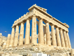
Ruins are the most obvious sign of ancient Athens, and the most famous of these is the Acropolis(卫城). The Acropolis is a large hill that was the center of life in Athens. On its slopes were temples, monuments, and theaters. From the top, you can see how the urban area of Athens stretches out in every direction.
On the top of the Acropolis is the Parthenon. This was once a huge temple to Athena, the city’s patron. It was first completed in 432 B.C., but has been damaged and destroyed several times. However, visitors can still see the “tricks” used in building the Parthenon. The columns along the outside lean inward, and are slightly fatter in the middle. The temple is also higher in the middle than on the sides. All these effects make the Parthenon look perfectly straight from a distance.
Only a block away from the Acropolis is the neighborhood of Plaka. The area, with its little shops and restaurants, is very popular with both tourists and locals, and is an important part of modern Athenian culture. Many great thinkers, writers, and political leaders lived in ancient Athens. The ruins of their homes and favorite spots are scattered throughout the busy port city. The hill where St. Paul addressed early Christian Athenians is located near the Acropolis. Great thinkers such as Perikles and Demosthenes spoke to the civil assemblies held at the Pnyx Hill. Today the Pnyx is an open-air theater for light and sound shows.
Tourism is very important to people who live in modern-day Athens. Thousands of people come every year to see these ruins and to tour the many museums that house artifacts from ancient times. This provides many jobs and brings money into Athens, which helps the city pay for improvements. Athenians take pride in the accomplishments of their ancestors, and people from all around the world come to admire them. By looking around the city today, we can imagine what life was like in ancient Athens.
1. Which of the following statements is INCORRECT about the city of Athens?| A.The culture of the city is a mixture of the old and modern. |
| B.Traces of the ancient city can still be found |
| C.Ruins and modern hotels co-exist in the city. |
| D.All the temples are not far away from air-conditioned hotels. |
| A.naughty acts | B.confusing constructing skills |
| C.skillful constructing methods | D.constructing materials |
| A.offering job opportunities to Athenians |
| B.enriching Athenians by providing accommodation for tourists |
| C.enabling Athenians to improve the infrastructures |
| D.making Athenians proud of their ancestors |
| A.Tourism in Athens | B.Athens: Then and Now |
| C.Historic Interests in Athens | D.The Magic of Ancient Athens |
Athens----- the name brings to mind buildings with tall, white columns and statues of Greek gods and goddesses. Museums take visitors back to the time of ancient Greece. When
The history of Athens is tied to mythology. The god
The Acropolis, or “ high city”, stands on a hill overlooking the city. Western civilization’s most important ancient monument was built by Pericles, the leader of Athens from 461-421BC. He spared no expense when he constructed the buildings of the Acropolis. He used only the
More treasure of ancient Greece lies in the National Archeological Museum. Opened in 1874, the museum contains the best collection of Greek art in the world. It is crammed with treasures ------ more
5 . Ship tourism to Antarctica is on the rise: More than 35,000 tourists are expected to visit Antarctic this summer. In 1992-1993, 6,750 visited Antarctica, according to the Antarctica Treaty. All of this tourism, however, is putting both tourists and the environment in great danger.
Among the tourist ships that visit the continent, the Explorer, a Canadian ship, was one of the first. Put to use in 1969, it was built to carry tourists to Antarctica. Last week, however, it became the first commercial passenger ship to sink beneath the waters. Fortunately, all of the passengers and crew members were rescued from the ship. However, the sunken ship endangered the Antarctic’s fragile(脆弱的) environment. The ship was estimated to be holding 48,000 gallons of fuel.
The accident was not unexpected. Both the US and UK had warned a conference of the Antarctic Treaty member countries in May that the tourism situation in this area was a potential disaster. The US said in a paper, people “should take a hard look at tourism issues now, especially those related to ship safety.” Although the Antarctic seas are relatively calm, floating ice causes a potential threat to ships. The owner of the Explorer blamed the sinking on a fist-like hole in the ship created by ice.
Many of the other large ships now visiting Antarctica are not designed especially against thick ice. Such ships generally can only come to the continent in summer. But the tourist rush is pushing ships into dangerous situations. “The increasing number of ships operating in Antarctic means that the ship are under great pressure to get there in time for the key visiting sites,” the British government wrote in a paper at the meeting of member countries.
As a natural frontier, Antarctica is in a messy legal situation. There are no obvious answers as to who is responsible for dealing with the threat that tourist may cause to human life and the environment.
There is no coast guard for Antarctica. Do we want it to become Disneyland, or do we need some controls?
1. Which of the following is true according to this passage?| A.Antarctica tourism has a history of about 17 years. |
| B.The number of tourists to the Antarctic is over 5 times as large as that of 17 years ago. |
| C.The tourism boom has caused holes in the floating ice in the Antarctic. |
| D.The Antarctica Treaty is responsible for the environmental problems. |
| A.led to a conference about the tourism situation in the Antarctic. |
| B.was caused by the rough seas |
| C.had been predicted |
| D.did harm to the Antarctic. |
| A.people had better not make a tour of the Antarctic |
| B.ships to the Antarctic should be built strong enough |
| C.there should be legal controls over tourism in the Antarctic |
| D.the Antarctic’s environment is fragile to be protected |
6 . One picture in the Wonder Book of knowledge I had as a little boy showed a man reading a book while floating in the Dead Sea. What a miracle! How would it feel to lie back in water so thick with salt that it was impossible to sink?
Fed by the Jordan River and smaller streams, the Dead Sea is the lowest point on the earth’s surface, and its water is ten times saltier than the Mediterranean. With evaporation its only outlet, salt and other minerals become super-concentrated.
Earlier this year, I drove down the long, steep hill to realize my dream. The shoreline was a broad area of bare salt-mud, but the water edge was far out of sight. Had somebody pulled the Dead Sea’s plug? I wondered. Eli Dior, an Israeli official, explained the problem: “The Dead Sea is drying up. Every year, the surface drops about one meter, and as the water level falls, shadow areas are left high and dry.”
Over the last half-century, the five neighboring countries have collectively diverted nearly all the water flowing into the Dead Sea to meet human and agriculture needs. Result: the Dead Sea is being emptied.
With population in the region set to double at least in the next 50 years, there is little hope of restoring the water being diverted for human consumption. No country has a drop to spare for the Dead Sea, where they know it will just evaporate. To dream of opening the dams and restoring natural balance is plainly unrealistic.
Yet one ambitious high-tech dream may turn out to be not only the salvation of the Dead Sea but also a ticket to peace around its shores. The “Red-Dead” is a proposed $5 billion project to bring sea water some 240 kilometers by pipeline and canal from the Red Sea to the Dead Sea. The Red-Dead may be the only solution, but even if the project is carried out successfully, the Dead Sea will be 10 to 20 meters lower than now and two thirds of its current size.
Whatever the future holds, the Dead Sea’s magical mix of sun, mud, sea and salt will surely survive. Many might complain that the Dead Sea is half empty—but for me the Dead sea will always be half full.
1. What’s the passage mainly about?| A.Dead Sea – miracle of the world. |
| B.Save the environment of the Dead Sea. |
| C.Slow shrinking of the Dead Sea. |
| D.Why is the Dead Sea so salty. |
| A.a severe reduction of the water flowing into the sea |
| B.rapid evaporation of the water in the Dead Sea area |
| C.the increasing quantity of water drawn from the sea |
| D.very low annual rainfall in the Dead Sea Area |
| A.With no outlet to any ocean, the Dead Sea has become by evaporation most dense waters on earth. |
| B.Though burdened with the growing population, the neighboring countries haven’t cut off the sources of the Dead Sea. |
| C.All the countries in the area will consider diverting less water from the Jordan River. |
| D.The Red-Dead Project has not only brought water to the Dead Sea, but peace to the area as well. |
| A.If the Dead Sea dried up, great natural disasters would happen in the region. |
| B.The Dead Sea will not survive no matter what people do to save it. |
| C.The five neighboring countries should stop diverting water from the Jordan River. |
| D.Though the Dead Sea is shrinking gradually, it will not die. |
Iceland shows off nature
Found just south of the Arctic Circle, it’s far from the northernmost country on Earth. But as a travel destinations, Iceland is on top of the world.
Known as‚ “the land of fire and ice”, the country has many natural wonders. As the Today website put it, “It is
As the world was reminded when the Eyjafjallajokull volcano erupted six years ago, Iceland is a country “still in the making, and few other places offer the same opportunities to see the earth
Ice is Iceland’s other big attraction-to be exact, the huge glaciers which travel toward the coast,
On Sept 28, the country’s capital Reykjavik decided to turn off all streetlights for an hour at night to give people a unique chance to enjoy the northern lights. Thanks to the glaciers and the dark sky, the bright, colourful
And
“The beast in Iceland, with its harsh(严酷的) nature and bitter, ever-changing weather. We cannot escape it,” Haraldur Jonsson, an Icelandic artists, told the Observer newspaper while describing his inspiration. “So we find ways to live with it. We
| A. recently B. estimated C. employing D. definition E. confusing F. updated G. scientific H. argument I. depending J. distinct K. finally |
Most of us learn at primary school that there are seven continents, but the next generation of kids may be adding one more to that list.
According to a recent paper published
Zealandia is
The small country is the only part of Zealandia that isn’t underwater, but the paper’s authors want the huge landmass to be recognized worldwide as its own continent.
“The
Scientists discovered Zealandia all the way back in 1995, then started extensive research on the area
But who decides on what is a continent and what isn’t? There is, in fact, no official organization that does. Some countries’ schools teach that there are six or even five continents. This changes
Due to their
And to make things even more
This
But will the world take the same notice of Zealandia? The best way to tell is to keep an eye on our textbooks.
9 . Mapping Antarctica
Antarctica was on the map long before anyone ever laid eyes on it. Nearly 2,400 years ago, ancient Greek philosophers such as Aristotle believed that a great continent must exist at the bottom of the world. They though it was needed to balance out the continents at the top of the world. In the 1500s, mapmakers often included a fanciful continent they referred to as Terra Incognita(Latin for “unknown land”) at the bottom of their maps. But it was not until the 1800s -----after explorers had sighted and set foot on Antarctica----- that mapmakers got down to the business of really mapping the continent, which is one—and—a –half times rhe size of the U.S..
While the coastline could be mapped by ships sailing around the continent, it took airplanes—and later, satellites---to chart Antarctica’s vast interior(内陆). That job continues today. And it is a job that still require a mapmaker, or cartographer, to put on boots and head out into the wild.
Cole Kelleher is familiar with that. He is a cartographer with the Polar Geospatial Center(PGC), which is based at the University of Minnesota and has a staff at McMurdo Station. PGC teamed up with Google to use the company’s Trekker technology to capture images of Antarctica for the Internet giant’s popular feature, Street View. A Trekker camera, which is the size of a basketball, is set about two feet above a backpack. The camera records image in all directions. “It weighs about 50 pounds. I was out for two and a half days, hiking 10 to 12 hours each day,” says Kelleher. It was hard work, but really an incredible experience.” According to Kelleher there are plans to use the technology to create educational apps for museums.
The PGC staff at McMurdo Station provides highly specialized mapmaking services for the U.S. Antarctic Program. For one project, Kelleher used satellite images to map huge cracks in the ice. That helped a team of researchers know whether they could safely approach their field camp on snowmobiles. Another recent project was to help recover a giant, high—tech helium(氦气) balloon used to carry scientific instruments high into the atmosphere. These balloons are launched in Antarctica because there is no danger that they will hurt anyone when they fall back down to Earth. Using satellite images, Kelleher and colleagues created maps of where the balloon could be found.
Antarctica may no longer be Terra Incognita, but it still holds countless mysteries. Cartographers and the maps they make will continue to be essential in helping scientists unlock those secrets.
1. From the passage, we can infer that Antarctica was on the map in the 1500s when________.| A.mapmakers knew it was much larger than the U.S. |
| B.Aristotle named the continent Terra Incognita |
| C.no one had ever seen or been to the continent |
| D.it was such an interesting continent as was often referred to |
| A.It needs much work for the mapmakers to head out into the wild. |
| B.The interior can only be mapped by planes and satellites. |
| C.It is relatively easy to map Antarctica’s coastline by ship. |
| D.Antarctic is a vast but still mysterious continent. |
| A.to capture images of Antarctica for Street View |
| B.to test the company’s Trekker technology |
| C.to create educational apps for museums |
| D.to hike for an incredible experience |
| A.satellite images which are used to map huge cracks in the ice |
| B.a high-tech helium balloon for carrying scientific instruments |
| C.how to safely approach the researcher’s field camp and the balloon |
| D.the specialized mapmaking services provided by the PGC staff |


