Every year, around 30 million visitors swarm into Venice, a place of under 50,000 residents. The population has shrunk by 70 percent in the past 70 years in Venice,
Burano—a one-square-mile island in the north lagoon—draws thousands of visitors daily. They take a 40-minute vaporetto (waterbus) ride from Venice
Now, as residents on the island, some Buranelli are fighting back,
Life on Burano has revolved around the water. A fishing settlement with a history
Yet
“I’m proud of my work but I’m also aware that in a few years there won’t be anyone left
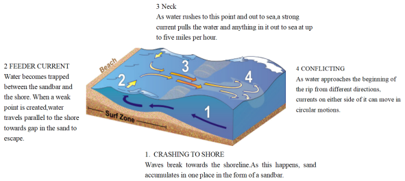
2 . WHAT ARE RIP CURRENTS?
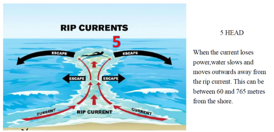
Rip currents are like the rivers of the sea, transporting water near the shore back out into the ocean depths. The presence of these currents can be hidden by the wild movements of the surrounding waves. This means that as well as carrying seaweed and pieces of materials quickly out to sea, they can rapidly sweep away even the strongest swimmers. Around 80 percent of all lifeguard rescues are caused by powerful rip currents pulling a swimmer into danger.
If you find yourself being pulled out to sea by an unsuspected rip current, you should remain calm, focus on staying afloat and, if you can, swim parallel to the shore. Your instincts might tell you to swim towards land, as this is where you’re aiming to get to, but the current will be too strong to swim against. Instead, aim to move across the current and into slower flowing water next to it. A rip current may only pull you just past the breaking waves, but in some cases they can take you hundreds of metres offshore. The strength of currents can be hard to predict, so it’s safest to stay on lifeguarded beaches and not to swim if you see any indication of a rip current.
| A.prevent you from swimming into danger | B.transport water out into the ocean depths |
| C.clear away seaweed and pieces of materials | D.warn lifeguards against rescue in rip currents |
| A.difference between various currents | B.two types of zones off shore |
| C.an ideal route to surf in safety | D.how rip currents form |
| A.1000 metres off the shore beyond “HEAD”. | B.The channel through the gap in a sandbar. |
| C.The location where a red flag is erected. | D.Over the narrow stretch of a sandbar. |
| A. double B. intense C. pressures D. stock E. agriculture F. trapped G. withdrawal H. availability I. drive J. expanding K. rising |
Throughout history, people have fought bitter wars over political ideology, national sovereignty and religious expression. How much more
Less than three percent of the planet’s
Global
1.
| A.In 1815. | B.In 1848. | C.In 1850. | D.In 1855. |
| A.High school education. | B.Two-year study programs. |
| C.100 education programs. | D.Four-year college programs. |
| A.California has the most state colleges and universities in America. |
| B.California is a large city with more than 4, 000, 000 people. |
| C.California is the largest state in land area throughout America. |
| D.California has only a few high-technology companies. |
5 . Hunting to Farming Is Not Necessarily Good
A. support B. effectiveness C. expanding D. escape E. reached F. questioning G. switched H. control I. recording J. allowed K. inferring |
Shifting from hunting to farming made life 50 percent more difficult for humans, a study by Cambridge University suggests. Although farming
“For a long time, the shift from hunting to farming was assumed to represent progress, allowing people to
Previous studies suggested the adoption of farming grew up to help cope with
1.
| A.A promotion of outdoor clothes. | B.An introduction of West Virginia. |
| C.A weekend vacation to a famous resort. | D.A free trip to an unknown destination. |
| A.Regretful. | B.Frustrating. | C.Worthwhile. | D.Comfortable. |
| A.Mystery trips. | B.Outdoor adventures. | C.Social media. | D.Travel destinations. |
The ancient Chinese were stonewall masters. China
Currently, visitors can access only about three kilometers of the wall, but about 22 of the
It once served as the southern gate of ancient Nanjing, a 15,168-square-meter fortification that contained four layers of defenses, as well as three grand castles,
| A. approach B. architectural C. captured D. complicated E. defensive F. defined G. extension H. houses I. reflect J. shades K. status |
Why India’s ‘Pink City’ is a Photographer’s Heaven
The city of Jaipur is one of India’s wonders. It
A romantic dusty pink type—which has
Walking in glass skyscrapers for century-old royal palaces and historic castles, the pair—who have 130,000 Instagram followers between them—said that the images they
For the photographers, one of the city’s most fascinating features is the light pink coloring of its buildings. “The first gates you see when you enter are pink,” said Wong. “Once you’re through, everything around you varies in different
The building is a(n)
9 . Mapping Antarctica
Antarctica was on the map long before anyone ever laid eyes on it. Nearly 2,400 years ago, ancient Greek philosophers such as Aristotle believed that a great continent must exist at the bottom of the world. They though it was needed to balance out the continents at the top of the world. In the 1500s, mapmakers often included a fanciful continent they referred to as Terra Incognita(Latin for “unknown land”) at the bottom of their maps. But it was not until the 1800s -----after explorers had sighted and set foot on Antarctica----- that mapmakers got down to the business of really mapping the continent, which is one—and—a –half times rhe size of the U.S..
While the coastline could be mapped by ships sailing around the continent, it took airplanes—and later, satellites---to chart Antarctica’s vast interior(内陆). That job continues today. And it is a job that still require a mapmaker, or cartographer, to put on boots and head out into the wild.
Cole Kelleher is familiar with that. He is a cartographer with the Polar Geospatial Center(PGC), which is based at the University of Minnesota and has a staff at McMurdo Station. PGC teamed up with Google to use the company’s Trekker technology to capture images of Antarctica for the Internet giant’s popular feature, Street View. A Trekker camera, which is the size of a basketball, is set about two feet above a backpack. The camera records image in all directions. “It weighs about 50 pounds. I was out for two and a half days, hiking 10 to 12 hours each day,” says Kelleher. It was hard work, but really an incredible experience.” According to Kelleher there are plans to use the technology to create educational apps for museums.
The PGC staff at McMurdo Station provides highly specialized mapmaking services for the U.S. Antarctic Program. For one project, Kelleher used satellite images to map huge cracks in the ice. That helped a team of researchers know whether they could safely approach their field camp on snowmobiles. Another recent project was to help recover a giant, high—tech helium(氦气) balloon used to carry scientific instruments high into the atmosphere. These balloons are launched in Antarctica because there is no danger that they will hurt anyone when they fall back down to Earth. Using satellite images, Kelleher and colleagues created maps of where the balloon could be found.
Antarctica may no longer be Terra Incognita, but it still holds countless mysteries. Cartographers and the maps they make will continue to be essential in helping scientists unlock those secrets.
1. From the passage, we can infer that Antarctica was on the map in the 1500s when________.| A.mapmakers knew it was much larger than the U.S. |
| B.Aristotle named the continent Terra Incognita |
| C.no one had ever seen or been to the continent |
| D.it was such an interesting continent as was often referred to |
| A.It needs much work for the mapmakers to head out into the wild. |
| B.The interior can only be mapped by planes and satellites. |
| C.It is relatively easy to map Antarctica’s coastline by ship. |
| D.Antarctic is a vast but still mysterious continent. |
| A.to capture images of Antarctica for Street View |
| B.to test the company’s Trekker technology |
| C.to create educational apps for museums |
| D.to hike for an incredible experience |
| A.satellite images which are used to map huge cracks in the ice |
| B.a high-tech helium balloon for carrying scientific instruments |
| C.how to safely approach the researcher’s field camp and the balloon |
| D.the specialized mapmaking services provided by the PGC staff |
10 . Now elsewhere in the world, Iceland may be spoken of, somewhat breathlessly, as western Europe's last pristine wilderness. But the truth is, once you're off the
When the opportunity arose in 2003 for the national power company to enter into a 40-year
Ostensibly, the Alcoa project was intended to save one of these dying regions— the remote and sparsely populated east— where the way of life had steadily
The contract with Alcoa would infuse the region with foreign
| A.beaten | B.explored | C.expired | D.centered |
| A.so | B.when | C.if | D.as |
| A.government | B.inhabitants | C.countryside | D.scale |
| A.designed | B.retained | C.exploited | D.preserved |
| A.stage | B.contract | C.transition | D.prosperity |
| A.gave up | B.jumped at | C.rushed to | D.made up |
| A.revolving | B.developing | C.Stirring | D.Initiating |
| A.transferred | B.declined | C.grew | D.reformed |
| A.preferred | B.presented | C.resisted | D.imposed |
| A.wiped out | B.held up | C.kept down | D.put aside |
| A.priceless | B.superficial | C.worthless | D.negative |
| A.investment | B.Exclusion | C.invasion | D.landscape |
| A.socially | B.immediately | C.accidentally | D.potentially |
| A.stabilize | B.wreck | C.diversify | D.consolidate |
| A.force | B.wheel | C.instructor | D.signal |


