1 . The Silk Road is arguably the most famous long-distance trade route of the ancient world. This passage connected Europe in the West with China in the East, and allowed the exchange of goods, technology, and ideas between the two civilizations. Although merchants could make huge profits travelling the road, it was not without risk.
The main Silk Road started in Chang’an (known today as Xi’an), the early Han capital. Travelers commencing their journey from this city could take a northern route that would take them across China’s northwestern provinces. After this, they would face the Gobi Desert, arguably the greatest danger of the Silk Road.
The Gobi Desert, the largest desert in Asia, consists mainly of rocky, hard earth. This feature made it easier for traders to travel across, compared to sandy deserts like the neighboring Taklamakan Desert. Like other deserts, the Gobi Desert is dry and hot, and therefore the biggest challenge travelers faced was obtaining enough water for themselves as well as for their camels.
So, rest stops were created along the route, allowing travelers to rest, eat and drink. These places also promoted the exchange of goods, and even ideas, amongst the travelers who stopped there. Usually, the rest stops were placed within a day’s journey of each other. In this way, travelers could avoid spending too much time in the desert, which would make them targets for robbers, another danger of the Silk Road.
Once through the Gobi Desert, travelers would continue their journey into Iran, Turkey, and finally Europe. While this part of the journey may have been less dangerous, it is not entirely without its perils (风险).
1. The underlined word “it” in the first paragraph refers to _________.| A.making huge profits | B.traveling the Silk Road |
| C.exchanging goods and ideas | D.connecting different civilizations |
| A.The desert’s surface was easier to walk on. |
| B.Camels for transportation were easier to find. |
| C.It was smaller and could be crossed in less time. |
| D.There were more natural water sources available. |
| A.Travelers were offered free accommodation. |
| B.They were located around the edges of the desert. |
| C.They were shared by travelers from different countries. |
| D.Exchanging goods and ideas there was entirely without risk. |
| A.The origins of the Silk Road. |
| B.The benefits of the Silk Road. |
| C.The difficulties faced by Silk Road travelers. |
| D.The cultural exchanges among Silk Road travelers. |
2 . Most of Florida is a flat peninsula (半岛) with water on three sides and houses built as close to the shoreline as possible. For one thing we are more frequently the target of hurricanes than any other state; for another, our geography makes us more easily to be hurt by rising seas.
A news story about climate change in Florida popped up. Historically, scientists believed mangroves (红树林) didn’t live farther north than Cedar Key, in the middle of Florida’s Big Bend. But that’s not the case anymore. Samantha Chapman, a biology professor who’s been studying how Florida’s mangroves have been migrating (迁移), found them up near the St Mary’s River, which forms the border between Florida and Georgia. It seems that they soon be marching through Georgia and becoming a thriving new component of coastal habitats.
But a coastal biologist named Blair Witherington took issue on the matter. The mangroves weren’t spreading into a new territory, he pointed out. They were entering areas that had been classified as saltmarsh (盐沼), where the landscape was dominated by cordgrass. Saltmarsh and mangrove create very different habitats that attract a very different set of animals. “When one community replaces the other, this diversity is lost,” Witherington remarked. Changing the animals’ habitat has the potential to influence the whole food chain, making a widespread difference.
What was driving this? “Mangroves can survive a short freeze, but not a prolonged, hard freeze. By combing through the weather records kept by the state’s orange juice industry, biologists have been able to document that Florida is having fewer prolonged hard freezes than it used to. Then the mangroves have adapted by expanding their range.” Samantha explained.
“They’ve adapted in another way, too. Not only are the mangroves spreading into areas that once were unfriendly to them, but they have also changed their life cycle to speed things up. Normally it takes them about 15 years of growth before they start making seeds. Now, as they get into these marshes, they’re producing seeds when they’ re only a couple of years old,” Samantha said.
The problem with having too many mangroves by the sea is that climate change may overwhelm them. A study by the US Geological Survey said sea level rise could wipe out mangroves all along the Florida coast. So, here’s the question we humans have to consider: Nature is finding ways to adapt to how we’ve changed the climate. What are we doing to adapt to it? Or at least slow it down?
1. What can we learn about the state of Florida?| A.It could be affected by high tides easily. |
| B.Its geography fuels shipbuilding industry. |
| C.Its houses are built in a high-lying but flat area. |
| D.It is often hit by tornadoes and suffers huge losses. |
| A.They migrate to warmer regions. |
| B.They are marching into a new habitat. |
| C.They form the border between Florida and Georgia. |
| D.They are introduced into Florida to prevent flooding. |
| A.Saltmarsh is fragile and requires urgent protection. |
| B.Florida includes a rich diversity of natural habitats. |
| C.The benefits of the mangroves outweigh their troubles. |
| D.Everything in the ecosystem is connected complicatedly. |
| A.What mangroves had to face in their habitats. |
| B.Whether mangroves had influence on other plants. |
| C.How mangroves adapted to the changing environment. |
| D.Why mangroves had a different life cycle in marshes. |
| A.Human beings are supposed to worship nature. |
| B.It is urgent to grow more mangroves along coastlines. |
| C.Measures against mangroves’ migration are far from enough. |
| D.What we should do to stop the climate change is still up in the air. |
3 . To understand the effect of ice melting (融化) around the world we first have to understand what an ice sheet actually is. Covering 5.4 million square miles in Antarctica (南极洲) and 656,000 square miles in Greenland, an ice sheet is actually a huge land of ice from the Ice Age. These sheets form in areas where snow that falls in winter does not melt entirely over the summer. This ice, home to different species of animals, is now melting at a rate that cannot support the life it currently holds.
Many of these creatures rely on ice sheets as land for resting, hunting and protection, yet as the size decreases, they are forced out of their homeland in search of other land on which to live. Often this means journeys to search for food and an imbalanced ecosystem happens when different species are forced together onto the coast.
Since the 1990s, the deer population has dropped by 56 per cent—climate change has caused warmer temperatures over winter setting off rainfall instead of snow, which freezes more quickly underfoot and makes it harder to walk and search for food. In the summer, frozen layers of land melts and releases trapped diseases which bring death to animals. A similar situation has fallen on the polar bears who suffered a 40 per cent population loss between 2001—2010.
Quite apart from these problems, the threat of sea levels rising if the ice caps were to disappear is approaching. If the Greenland Ice Sheet melted, the sea level would rise around six meters, and if the Antarctic Ice Sheet melted, sea levels would rise by around 20 feet. As a matter of fact, sea levels have risen about eight inches since 1880, three of which we’ve gained over the last 25 years. This seemingly small amount has already caused dangerous flooding, loss of farmland and more deadly storms.
While we’re still a long way from losing the ice sheets all together, we’ve already lost too much and if we don’t take climate change seriously now, we will certainly hit the point of no return.
1. What is an ice sheet according to the passage?| A.It is an area where ice never melts in summer. |
| B.It is a land of ice that covers all Greenland. |
| C.It is a large area of ice that exists for centuries. |
| D.It is an ice world for animals to live on. |
| A.It makes it easier to travel to other land. |
| B.It increases the population of sea animals. |
| C.It makes their surroundings more comfortable. |
| D.It causes hunger and illness among animals. |
| A.Ice sheet will soon disappear from the Earth. |
| B.Sea levels are rising faster in recent years. |
| C.Greenland will be the first to lose all its ice. |
| D.All natural disasters happen due to sea level rise. |
| A.Effect of Melting Ice Sheets | B.Ice, Sea and Animals |
| C.Greenland and Antarctica | D.Changes of Sea Levels |
4 . Sea level, also referred to as mean(平均的) sea level is the level at which the oceans exist when averaged between high and low tides. It is calculated by measuring the level of the oceans over long periods of time and under all types of weather conditions.
| A.The measurement of mean sea level has many uses. |
| B.These devices measure the average height of the sea. |
| C.The actual level of the sea is constantly changing as tides rise and fall. |
| D.A change in the height of the land can also affect the measurement of the sea. |
| E.It is used to calculate the height or depth of any point on the Earth's land surface. |
| F.Several terms are used to describe the changing relationships between sea level and dry land. |
| G.While most of the land lies above sea level, there are still places that actually exist below it. |
5 . Danakil Depression is an extremely hot, bone dry, lava - spewing hellhole with lakes of acid. Somehow, there's still life.
It's nicknamed the “Gateway to Hell,” and it's the hottest place on Earth, with temperatures recorded as high as 131 degrees Fahrenheit, and that's not even taking into account the heat coming from the ground and lava-spewing volcanoes.
Unbelievably, researchers looking for life in this barren hellscape(地狱) have found evidence that two extremophile types of bacteria have made their home in the Danakil Depression, reports the BBC.
It was no small feat(功绩) for researchers to make the discovery. There's the extreme heat and the threat of slipping into a hot pool of acid, sure. But spending any time in Danakil also requires wearing gas masks due to the clouds of harmful gas.
Organisms(生物) were found in two separate locations, one of which was an acidic pool with a zero pH, a new extremophile record. It's the most acidic place where life has been found anywhere on Earth. In fact, it's such an extreme place that only referring to these organisms as “extremophiles” doesn't go far enough.
| A.Surely, nothing survives here. |
| B.Somehow, life has found a way. |
| C.To make matters worse, it rarely rains. |
| D.It is also one of the lowest places on the planet. |
| E.The discovery shows well for the prospect (前景) of finding life on other worlds. |
| F.It took years of planning before researchers felt it was safe enough to brave sample collection. |
| G.It has developed as a result of Africa and Asia moving apart, causing rifting and volcanic activity. |
6 . The huge stone human statues of Easter Island have fascinated the world for centuries, but now a new research has solved one of the biggest mysteries (谜团) why the statues are located where they are.
Easter Island has more than 600 statues, built by different families hundreds of years ago. It is thought the statues represent their ancestors. However, it was previously a mystery why many of them were around the coast. While scientists have suggested the sites may have a connection with the island’s resources (资源), the latest research is the first attempt to look into such views.
Researchers focused on the east of the island, where various resources are located, and looked at the distribution (分布) of 93 statues built before European sailors arrived in the 18th century. After finding no connection with the rock used for the construction, they considered whether the statues were found near other important resources.
Things became interesting when they checked where the islanders got their drinking water. The island has no long-standing streams or lakes. However, fresh water brought by storm could pass through the ground and go deeper into the underground water system. “It is sort of amazing at low tide (潮水) when the water goes down, suddenly there are streams running off at different sites right at the coast that is just pure fresh water,” said Lipo. “We noticed, actually, when we were doing an investigation on the island, that we saw horses drinking from the ocean.”
The results of the new research—published in the journal Plos One—found that closeness to freshwater sites is the best explanation for the location of the statues, including why they appear inland as well as on the coast. “Historical records show the islanders also made wells to get drinking water,” said Lipo, adding that historic wells explained some inland statue locations that were apparently without natural water resources.
The results, said Lipo, made sense, as drinking water is important for the islanders and it is not practical to have to walk miles to get it.
1. The new research is thought to be unique because it is the first_________.| A.to find the statues located around the coast |
| B.to connect the statues with the islanders’ ancestors |
| C.to examine the connection between statues and resources |
| D.to suggest a connection between statues and resources |
| A.To suggest that the horses have got used to sea water. |
| B.To provide evidence of drinking water on the coast. |
| C.To describe an interesting thing which is rare to see. |
| D.To show that the island has a great shortage of water. |
| A.The islanders had learned to dig wells. |
| B.The islanders could rely on inland lakes. |
| C.The streams would run off at different site. |
| D.The islanders could walk miles to get water. |
7 . There are around 100 tribes(部落)that live in global isolation, mostly in South America and India. The Sentinelese have lived on one of the Andaman Islands in Eastern India for 60, 000 years. They protect their island by fighting against people from outside. Their language is different from any other known language. Another Andaman tribe is the Jarawa. In the past, they were independent and fought against anybody trying to make contact with them. But in 1998, the Indian government built a road across their land, and since then, they’ve had more contact with the outside world.
Some Amazon tribes avoid contact because of unhappy memories. The Mashco-Piro left their vegetable gardens after rubber companies killed most of their tribe at the beginning of the 20th century. Those who survived became nomadic(游牧的)and started hunting animals in the forest.
The Awa live in the Amazon forests ofBrazil. Out of 350 members, 100 have no contact with the outside world. They left their villages and adopted a nomadic lifestyle around 1850 to escape attacks by Europeans. In the following years, farmers in nearby communities started cutting the trees to expand their farmland. The Awa lost most of their hunting land. The few Amazon tribes that still exist are fighting to keep their traditional way of life.
Survival, an organization that fights for the rights of tribal people, says that uncontacted tribes are the most vulnerable(弱势的)humans on the planet and that’s why their environment should be unavailable to the rest of us. After years of pressure, the organization got Brazil’s government to clear non-natives from the Awa land. All non-Awa people are leaving so the tribe can get their forest back.
But some think it's impossible for tribes to stay isolated forever in a connected world. Contact will be made one day. So the question is:Whose choice should it be, ours or theirs?
1. What can we learn about the Sentinelese from the first paragraph?| A.They resist contact from the outside world. |
| B.They speakthe same language as the Jarawa. |
| C.They are wild about fighting with other tribes. |
| D.They have got help from the Indian govemment. |
| A.To protect their hunting land. | B.To search for food sources. |
| C.To avoid threats from Europeans. | D.To maintain their original way of life. |
| A.The tribes should be left undisturbed. |
| B.The tribes should fight for more living space. |
| C.The cribes should live in harmony with nature. |
| D.The tribes should adapt to the connected world. |
| A.The Nomadic Tribes in the World | B.Seeking Survival of Tribes |
| C.The Unavailable Tribal Environment | D.Protecting the Tribal Forests |
8 . The twilight zone (朦胧地带) contains the largest and least explored fish stocks (储备) of the world’s oceans. Ranging from just below 200 metres to 1,000 metres deep, it is an interface between the well-studied sea life in the sunlit zone above and the ecosystems of the darkest territory below. It has a major role in removing carbon dioxide from the atmosphere and storing it for centuries or longer. The twilight zone is also known to the largest migration on Earth. Huge numbers of fishes and zooplankton (浮游动物) move hundreds of metres towards the surface each night to feed, before withdrawing back down at dawn.
Yet the zone is poorly understood — physically, biogeochemically and ecologically. Even the number of organisms that live there remains a mystery, let alone their diversity and function.
It is alarming, then, that this vast ocean domain is at risk in three ways-even before any of the potential consequences are understood. First, the world’s growing population has an increasing need for food. Second, sea-floor mining for minerals and metals could release waste into the region. And third, climate change is varying temperature, acidification and oxygen levels in ways that are likely to affect life there.
The twilight zone is hard Io study. Its organisms are difficult to sample and analyse, being thinly distributed, almost invisible and often fragile. They also live at pressures of up to 100 atmospheres, which poses problems for laboratory-based investigations.
Critics might argue that walers near coasts and above shelves are more deserving of study, given the huge environmental pressures there, as well as their importance to societies. And, of course, they need attention. Sadly, however, it is too late to avoid widespread environmental damage to these inshore regions. Instead, research efforts and local policies must aim at minimizing the worst effects.
By contrast, the twilight zone is almost left in its original condition. Moreover, the majority of it lies beyond national administration. This makes it of common interest and responsibility, and means that global agreement is necessary to manage it.
1. What can we learn about the twilight zone?| A.It has the least fish stocks. |
| B.It reduces atmosphere’s carbon dioxide. |
| C.It lies at the bottom of sea. |
| D.Il is located above the sunlit zone. |
| A.Where global warming leads us. |
| B.Why high food consumption arises. |
| C.How the twilight zone is threatened. |
| D.What impacts pollution has on ocean. |
| A.The twilight zone. | B.The inshore area. |
| C.Its original condition. | D.National administration. |
| A.International cooperation is essential. |
| B.Inshore regions deserve more attention. |
| C.Global agreement has been reached. |
| D.Study on the twilight zone is out of the question. |
Now rewind this picture 1,839 years. You are in the same seat, only you are watching classical Greek entertainment.
The city of Athens is a fun mix of the old and the new, the classic and the modern. Often a little shop is located next to the ruins of a temple, which is only a block from a large, air-conditioned hotel. The great city of 2,500 years ago is still visible today.
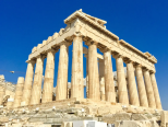
Ruins are the most obvious sign of ancient Athens, and the most famous of these is the Acropolis(卫城). The Acropolis is a large hill that was the center of life in Athens. On its slopes were temples, monuments, and theaters. From the top, you can see how the urban area of Athens stretches out in every direction.
On the top of the Acropolis is the Parthenon. This was once a huge temple to Athena, the city’s patron. It was first completed in 432 B.C., but has been damaged and destroyed several times. However, visitors can still see the “tricks” used in building the Parthenon. The columns along the outside lean inward, and are slightly fatter in the middle. The temple is also higher in the middle than on the sides. All these effects make the Parthenon look perfectly straight from a distance.
Only a block away from the Acropolis is the neighborhood of Plaka. The area, with its little shops and restaurants, is very popular with both tourists and locals, and is an important part of modern Athenian culture. Many great thinkers, writers, and political leaders lived in ancient Athens. The ruins of their homes and favorite spots are scattered throughout the busy port city. The hill where St. Paul addressed early Christian Athenians is located near the Acropolis. Great thinkers such as Perikles and Demosthenes spoke to the civil assemblies held at the Pnyx Hill. Today the Pnyx is an open-air theater for light and sound shows.
Tourism is very important to people who live in modern-day Athens. Thousands of people come every year to see these ruins and to tour the many museums that house artifacts from ancient times. This provides many jobs and brings money into Athens, which helps the city pay for improvements. Athenians take pride in the accomplishments of their ancestors, and people from all around the world come to admire them. By looking around the city today, we can imagine what life was like in ancient Athens.
1. Which of the following statements is INCORRECT about the city of Athens?| A.The culture of the city is a mixture of the old and modern. |
| B.Traces of the ancient city can still be found |
| C.Ruins and modern hotels co-exist in the city. |
| D.All the temples are not far away from air-conditioned hotels. |
| A.naughty acts | B.confusing constructing skills |
| C.skillful constructing methods | D.constructing materials |
| A.offering job opportunities to Athenians |
| B.enriching Athenians by providing accommodation for tourists |
| C.enabling Athenians to improve the infrastructures |
| D.making Athenians proud of their ancestors |
| A.Tourism in Athens | B.Athens: Then and Now |
| C.Historic Interests in Athens | D.The Magic of Ancient Athens |
10 . Deep in the middle of Sri Lanka, a massive column of rock reaches out from the green tropical forest. It is 660 feet tall and features frescoes (壁画), graffiti, and landscaped gardens.
The rock is known as Sigiriya and holds a special place in the island's cultural history.
It was established as the stronghold of a king over 1,500 years ago, and today the Sigiriya complex stands as one of the earliest preserved examples of ancient urban planning.
Located in the Central Province, the column of rock is somewhat central to the country. The rock is known as Sihagiri, meaning "Lion Rock", a nod to the giant animal carved from stone which greeted visitors at the entrance.
In 476 BC. King Dhatusena ruled over Sri Lanka. One of his illegal sons, Kashyapa, wanted the throne (王位). Kashyapa overthrew Dhatusena and drove his brother Moggallana to Southern India. Kashyapa crowned himself king in 477 BC.
King Kashyapa chose Sigiriya as his palace because its position was an advantage to the defensive stronghold, offering fantastic 360-degree views. Plans to build a city quickly unfolded and after several years, the Sigiriya complex had become a business center for the new King.
Sigiriya was both a palace and a fortress (堡垒); the overall complex featured five gates and measured just under 3 km by just over 1 km. The site plan consisted of a fort,an upper palace on the top of the rock,and lower palaces at ground level. The king also constructed gardens throughout,and for protection a river with walls surrounded the complex.
Frescoes decorate the western side of the rock, along with the mirror wall, a brick face covered in a highly-polished white plaster. When new, the wall was said to be able to produce Reflections.
Over time the Mirror Wall became a graffiti board, covered in verses written by visitors. Known as "Sigiri Graffiti", some of the messages date to the 8th century CE.
1. It is implied in the passage that Sigiriya was built to ______________.| A.preserve the culture of Sri Lanka | B.prove the ancient urban planning |
| C.keep the King from being attacked | D.protect the green tropical forest |
| A.have a reflection before the Mirror Wall |
| B.leave comments on the Mirror Wall |
| C.draw beautiful paintings of girls on the wall |
| D.be lost in thought before the Mirror Wall |
| A.Its entrance is carved like a lion. | B.Its gardens are at ground level. |
| C.Its western side is a mirror. | D.Its palaces are on the top of the rock. |
| A.The giant lions in Sri Lanka. | B.The pearl of the Indian Ocean. |
| C.The Lion Rock of Sri Lanka. | D.The mirror wall in a rock. |


